Serabit al Khadim, the Exodus, the Red Sea Crossing, and why Mount Sinai’s True Location was confused in Late Antiquity
Хатшепсут, Тутмос III, Эхнатон, Рамсес III и двойная стратегия Моисея против народов моря
Серабит-эль-Хадим, Исход, Разделение Красного моря, и почему истинное местоположение горы Синай было запутано в поздней античности

Serabit al Khadim, Temple of Hathor
Contents
Introduction
I. Mount Sinai (or Horeb): from the Pentateuch to Itinerarium Egeriae
II. The Exodus: Reconstruction of the Path and Textual Changes (?) from the Septuagint to the Masoretic Text
III. From Hatshepsut and Thutmose III to Akhenaten’s Monotheism, and from Merneptah (the Pharaoh of the Exodus) to Ramesses III
IV. Serabit al Khadim and the Temple of Hathor: a Major Egyptian Site
V. Straits of Tiran: Red Sea Crossing, World Politics, and Moses’ Formidable Double Stratagem
VI. Iranians, Macedonians, Aramaeans, Romans: Reasons for the Confusion about the True Location of Mount Sinai
VII. From Ptolemy’s Geography to Al Biruni’s Chronology
Содержание
Введение
I. Гора Синай (или Хорив): от Пятикнижия к Паломничеству Этерии
II. Исход: реконструкция пути и текстовые изменения (?) от Септуагинты к масоретскому тексту
III. От Хатшепсут и Тутмоса III до монотеизма Эхнатона и от Мернептаха (фараона Исхода) до Рамсеса III.
IV. Серабит-эль-Хадим и храм Хатхор: главное место Египта
V. Тиранский пролив: Разделение Красного моря, мировая политика и грозная двойная стратегия Моисея
VI. Иранцы, македонцы, арамейцы, римляне: Причины путаницы относительно истинного местоположения горы Синай
VII. От географии Птолемея к хронологии Аль Бируни
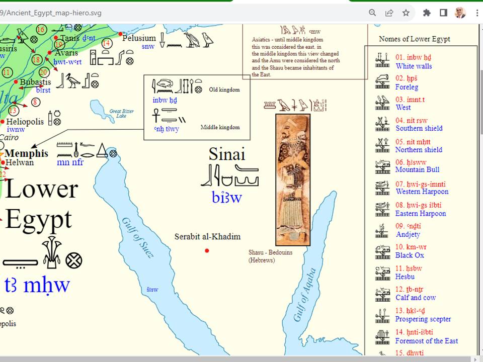
Biaw: part of Lower Egypt’s 14th ‘nome’ (administrative division)
Introduction
Mount Sinai and the Sinai Peninsula are not located where you think they are. Consequently and more importantly, the Ancient Hebrews and the Egyptians monotheists, who left with them, did not cross the Red Sea near the modern cities of Suez or Ismailia (Timsah Lake).
Certainly, I am not the first to state this fact. There have been several other explorers and researchers who first discussed the topic, examined closely all the related aspects, and even undertook expeditions to find out eventual remains of the true Mount Sinai, which is not located in the peninsula, which by mistake bears its name.
If I intend to herewith present a brief commentary on the topic, this is entirely due to my desire to underscore two points that ought to have been noticed long ago. I have to admit that the sojourn of the Ancient Hebrews in Egypt (Kemet/Mizraim) and their Exodus generated tons of publications and endless polarizations, particularly because the topics are a matter of common heritage and at times divergent traditions for Jews, Christians and Muslims. Different textual sources, distinct interpretations, and overreliance on later and apparently distorted traditions contributed to the slow formation of stereotypes that have been repeated for long.
The end result involved unfortunately the typical Western academic conventionalism and conformism, the demonization of pioneering explorers, and the vilification of any scholar who would question the supposedly sacrosanct conclusions of the modern academic disciplines. Even more confusingly, Western European painters and artists worsened the problem by producing terribly misleading representations of the Biblical stories onto which they merely projected their own illusions, delusions and unsubstantiated understanding of the historical past.
I. Mount Sinai (or Horeb): from the Pentateuch to Itinerarium Egeriae
Four (out of the five) books of the Torah detail the event that Reform Judaism (so: fake Judaism) calls ‘the founding myth’ of the Ancient Hebrews: Exodus, Leviticus, Numbers, and Deuteronomy. However, in spite of the numerous details, there is no topographical-geographical accuracy in these narratives that may have been written in an early form in the 11th-10th c. BCE, but the earliest composition of the presently preserved text is impossible to be dated before the late 6th and early 5th c. BCE. This fact, in and by itself, dramatically conditions the chances of the Biblical text to offer a shred of authoritative evidence, particularly if we take into consideration the great changes that had occurred in Egypt, Mesopotamia and Canaan, which are the main regions involved in the text. About:
https://en.wikipedia.org/wiki/Yehud_Medinata
https://en.wikipedia.org/wiki/Book_of_Exodus
https://en.wikipedia.org/wiki/The_Exodus
Modern Jewish and Christian commentators, failing to comprehend the span of time between the events described and the dates of the earliest composition and the ultimate compilation of the Biblical text, focused excessively on the 42 stations of the Exodus that are mentioned in Numbers 33, trying to eventually locate the stations of the Ancient Hebrews; this ended up in enormous confusion, because these locations are either broadly defined or described in relative terms.
One of these stations is Midbar Sin, i.e. the Wilderness of Sin; this expression is attested in Exodus 16:1 and 17:1, and in Numbers 33:11–12. I have to add that Sin is a toponym in this case. This is the earliest form of reference to the wider region where Mount Sinai is located. There is also reference to the Sinai Wilderness, which is found in Exodus 19:1–2 and in Number 10:12 and 33:15–16. But the identification of the sacred mountain with what is called Jabal Musa (Moses’ Mountains) in modern times is fully unsubstantiated and absolutely arbitrary.
Actually, German theologians of the school of Julius Wellhausen, after extensive examination of the four different historical sources of the Old Testament, noticed that the name ‘Sinai’ occurs only in two of them (i.e. the Jahwist and the Priestly sources); contrarily, in the other two sources (namely the Elohist and the Deuteronomist), the same always mountain is named ‘Horeb’. The etymology and the meaning of the name ‘Sinai’ are still a matter of debate, but the most commonly accepted opinion involves an association with Sin, the Assyrian-Babylonian aspect of the divine world that was symbolized with the Moon. In Neo-Assyrian times (1244-609 BCE), within the context of Sargonid monotheism, Sin became a symbol for the Assyrians, who explicitly considered themselves as the ‘Chosen People’ of the Only God, Assur. About:
https://en.wikipedia.org/wiki/Stations_of_the_Exodus
https://en.wikipedia.org/wiki/Wilderness_of_Sin
https://en.wikipedia.org/wiki/Zin_Desert
https://en.wikipedia.org/wiki/Mount_Sinai_(Bible)
https://en.wikipedia.org/wiki/Mount_Sinai#Islam
https://en.wikipedia.org/wiki/Mount_Sinai_(Bible)#Jabal_Musa
https://en.wikipedia.org/wiki/Documentary_hypothesis
https://en.wikipedia.org/wiki/Crossing_the_Red_Sea
https://en.wikipedia.org/wiki/Sources_and_parallels_of_the_Exodus
https://en.wikipedia.org/wiki/Textual_variants_in_the_Book_of_Exodus
https://en.wikipedia.org/wiki/Plagues_of_Egypt
https://en.wikipedia.org/wiki/Pillars_of_fire_and_cloud
Ancient Egyptian narratives, which antedate and may have served as point of reference for the Biblical text (notably the description of calamities such as “the river is blood”): https://en.wikipedia.org/wiki/Ipuwer_Papyrus
The two appellations (Hebrew: Har Sinay; Aramaic: Tura deSinay) are at the origin of the Quranic expressions Tur Saina, Tur Sinin, at-Tur and al-Jabal (just: ‘mountain’). However, the identification of the location is not a matter of the Quran, but of purely subjective and unsubstantiated opinions of Muslims who made the same mistake as the Christians of the times of the Eastern Roman Emperor Justinian I, who ordered the construction (548-565) of what is today the oldest continuously occupied Christian monastery (دير القدّيسة كاترين; Μονὴ τῆς Ἁγίας Αἰκατερίνης). Although the existence of monastic life in this region, as documented in the Itinerarium Egeriae (written ca. 385 CE), proves that the location was identified as the Mount Sinai at the time, nothing exists to demonstrate significant antecedence and historical continuity for this identification. No less than 1500 years separate the Exodus and the Christian nun Egeria, who traveled in the Orient and wrote down her itinerary. About:
https://en.wikipedia.org/wiki/Saint_Catherine%27s_Monastery
https://en.wikipedia.org/wiki/Egeria_(pilgrim)
https://en.wikipedia.org/wiki/Mount_Sinai_(Bible)#Suggested_locations
https://en.wikipedia.org/wiki/Mount_Serbal
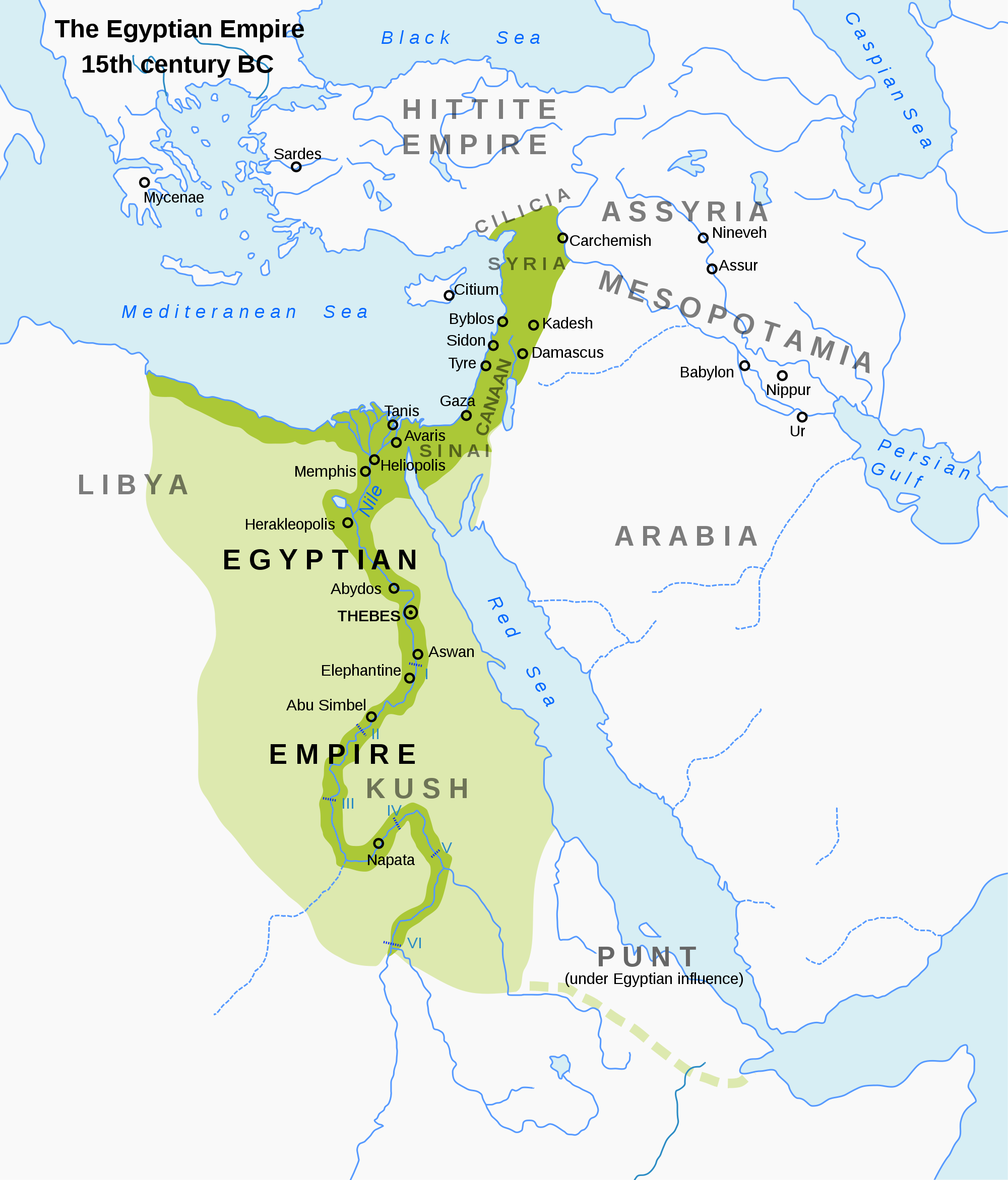
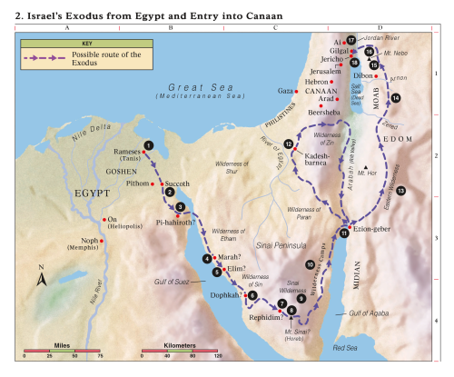
It is on such wrong maps of Egypt that the wrong reconstruction of the path of the departing Egyptian monotheists and Ancient Hebrews has been based. This map is entirely wrong, because it does not show a) the Egyptian oases, b) the Red Sea harbors of Ancient Egypt, c) North Sudan down to at least the fourth cataract of the Nile {which was an area in which the Ancient Egyptians at times were the sole rulers and at times interacted with the local Cushitic (Ancient Sudanese) kingdoms}, d) at least the western half of the so-called Sinai Peninsula (which was integral part of Egypt), e) the southern half of Canaan (which was either annexed to Egypt or ruled by vassal kings or princes), and f) large swathes of today’s Libyan territory where the Ancient Egyptians interacted with the local Berber princes, who often had significant positions and career in Kemet (Ancient Egypt).
Typically wrong (if not foolish) reconstruction of the path taken after the Exodus
Typically wrong (if not foolish) reconstruction of the path taken after the Exodus
Typically wrong (if not foolish) reconstruction of the path taken after the Exodus

Typical Freemasonic Protestant Anglo-Zionist absurdity and paranoia: they ‘think’ that the ‘departure’ (Exodus) started in the Valley of the Nile! Read the original legend of the forged map to laugh at will: «Jericho. Israel leave Elim (Exo.16:1) Tabernacle erected (Exo.40:17) Israel arrive at Sinai (Exo.19:1) Israel leave Sinai (Num.10:11) 1yr 2mth 15dy. 1yr 3mth 15dy. 2yr 1mth 1dy. 2yr 2mth 20dy. Punon. Moses ascends mount Sinai 7 times. Israel leave Egypt (Num.33:3) Israel spent 9 months constructing the Tabernacle. Spies enter the land – Kadesh (Num.13:20) 1yr 1mth 1dy. 1yr 1mth 14dy. 1yr 1mth 15dy. 2yr 1mth 14dy. 2yr 4mth. Passover (Exo.12:6) Passover (Num.9:1-3) Ritual Calendar established (Exo.12:2)»
A far more reasonable and more plausible itinerary based on common sense and closer study of all the related historical sources – not only the Biblical text.
II. The Exodus: Reconstruction of the Path and Textual Changes (?) from the Septuagint to the Masoretic Text
The reconstitution of the trajectory that the Ancient Hebrews and the Egyptian monotheists pursued after leaving Egypt produced an incredible number of books and articles, which are mostly delusional in their major assumptions, although they may contain countless pieces of historical truth. Modern scholarship refuted most of the efforts of reconstruction in the light of enormous mistakes that happen to be found in the Biblical text. Even the name that the Biblical author uses to denote the land where the Ancient Hebrews were settled in Egypt is otherwise unknown and meaningless in Hebrew (Goshen); several Egyptologists tried to offer potential interpretations, based on Ancient Egyptian toponyms and vocabulary.
The duration of the Hebrew sojourn in Egypt is also questionable. Consequently, even the date of the Exodus is debatable. In the past, scholars and religious propagandists preferred to date the event in the middle of the 15th c., which is highly improbable. After the documentation made available due to Orientalist research during the 19th and the early 20th c., a ‘lower’ date (middle to end of the 13th c.) seemed to be more plausible. In fact, anyone who attempts to write about the topic today without having first studied extensively original Ancient Egyptian sources relating to the rise and fall of the Egyptian monotheism (Atenism) at the time of the 18th dynasty is doomed to draw the wrong conclusions. About:
https://en.wikipedia.org/wiki/Land_of_Goshen
https://en.wikipedia.org/wiki/Jacob#In_Egypt
https://en.wikipedia.org/wiki/Joseph_(Genesis)#Family_reunited
https://biblicalstudies.org.uk/article_exodus_date.html
The various efforts of reconstruction of the path followed by all those who followed Moses in Yezi’at Mizrayim (יציאת מצרים/departure from Egypt) can be basically categorized into five main groups of modern scholars, namely those who support one of the following alternatives:
i- the Mediterranean Sea road;
ii- the northeastern confines of the Delta, north of the Bitter Lakes region;
iii- the eastern confines of the Delta, through the Bitter Lakes region;
iv- the northern end of the Gulf of Suez; and
v- the crossing of the Gulf of Aqaba.

Within each group there may be variants or sub-groups; for instance, in the fifth category, Ron Wyatt places the crossing in the area of Nuweiba, whereas Robert Cornuke proposed the idea of a land bridge at the Strait of Tiran.
The categorization encompasses another scholarly debate, namely the interpretation of the Ancient Hebrew term ‘Yam Suph’ (יַם-סוּף), which literally means ‘sea of the reeds’; these are the Ancient Hebrew words used in the Bible for the sea that Moses and his followers crossed during the Exodus. Now, the very serious problem is that the Septuagint version offers a rather bizarre translation of the term, rendering it in Alexandrian Koine as ‘Red Sea’ (Ερυθρά Θάλασσα). This inexplicable situation impacted the judgment of many researchers greatly, because some scholars took the Masoretic text as guide in their effort to reconstitute the Exodus route, whereas others accepted the Septuagint translation. In fact, the most original sources (Septuagint, Peshitta, and Samaritan Pentateuch) stick to the term ‘Red Sea’. About:
https://en.wikipedia.org/wiki/Yam_Suph
https://en.wikipedia.org/wiki/Koine_Greek
https://en.wikipedia.org/wiki/Red_Sea
https://en.wikipedia.org/wiki/Masoretic_Text
https://en.wikipedia.org/wiki/Samaritan_Pentateuch
https://en.wikipedia.org/wiki/Peshitta
https://en.wikipedia.org/wiki/Septuagint
https://en.wikipedia.org/wiki/Mizraim
https://en.wiktionary.org/wiki/מצרים
At this point, I must clarify that during the Antiquity, the term ‘Red Sea’ did not have the connotation that it has in modern times; this geographical term denoted the following bodies of water (as used with their meaning in modern languages):
a) the Red Sea,
b) the Persian Gulf, and
c) the Indian Ocean from the Eastern African coast lands to Indochina and Indonesia.
Within the limits of the present article, I cannot expand on the topic, but I have to underscore that the historical name was tantamount to a general description of what we would call today ‘the southern seas’.
All the same, only religious dogmatism, academic doctrinairism, ideological authoritarianism, and intellectual opinionatedness can lead so many scholars, explorers and religious schemers to such extreme disregard of few Biblical verses, which undeniably clarify the whole matter to some extent, totally canceling some of the above mentioned five options.
III. From Hatshepsut and Thutmose III to Akhenaten’s Monotheism, and from Merneptah (the Pharaoh of the Exodus) to Ramesses III
The verses 17 and 18 of the 13th chapter of Exodus help us recreate the Exodus route as pursued according to God’s will and following a miraculous intervention; the text reads:
“And when Pharaoh had sent out the people, the Lord led them not by the way of the land of the Philistines, which is near; thinking lest perhaps they would repent, if they should see wars arise against them, and would return into Egypt. But he led them about by the way of the desert, which is by the Red Sea: and the children of Israel went up armed out of the land of Egypt.” (English translation of the Vulgata)
(Septuagint: Ὡς δὲ ἐξαπέστειλε Φαραὼ τὸν λαόν, οὐχ ὡδήγησεν αὐτοὺς ὁ Θεὸς ὁδὸν γῆς Φυλιστιείμ, ὅτι ἐγγὺς ἦν· εἶπε γὰρ ὁ Θεός· μήποτε μεταμελήσῃ τῷ λαῷ ἰδόντι πόλεμον, καὶ ἀποστρέψῃ εἰς Αἴγυπτον. καὶ ἐκύκλωσεν ὁ Θεὸς τὸν λαὸν ὁδὸν τὴν εἰς τὴν ἔρημον, εἰς τὴν ἐρυθρὰν θάλασσαν, πέμπτῃ δὲ γενεᾷ ἀνέβησαν οἱ υἱοὶ Ἰσραὴλ ἐκ γῆς Αἰγύπτου.)
(Vulgata: igitur cum emisisset Pharao populum non eos duxit Dominus per viam terrae Philisthim quae vicina est reputans ne forte paeniteret eum si vidisset adversum se bella consurgere et reverteretur in Aegyptum. Sed circumduxit per viam deserti, quæ est juxta mare Rubrum: et armati ascenderunt filii Israël de terra Ægypti.)
(Masoretic text: וַיְהִי, בְּשַׁלַּח פַּרְעֹה אֶת-הָעָם, וְלֹא-נָחָם אֱלֹהִים דֶּרֶךְ אֶרֶץ פְּלִשְׁתִּים, כִּי קָרוֹב הוּא: כִּי אָמַר אֱלֹהִים, פֶּן-יִנָּחֵם הָעָם בִּרְאֹתָם מִלְחָמָה–וְשָׁבוּ מִצְרָיְמָה . וַיַּסֵּב אֱלֹהִים אֶת-הָעָם דֶּרֶךְ הַמִּדְבָּר, יַם-סוּף; וַחֲמֻשִׁים עָלוּ בְנֵי-יִשְׂרָאֵל, מֵאֶרֶץ מִצְרָיִם)
(English translation of the Masoretic text: And it came to pass, when Pharaoh had let the people go, that God led them not by the way of the land of the Philistines, although that was near; for God said: ‘Lest peradventure the people repent when they see war, and they return to Egypt.’ But God led the people about, by the way of the wilderness by the Red Sea; and the children of Israel went up armed out of the land of Egypt.)
(English translation of the Samaritan Pentateuch: And it came to pass, when Pharaoh had let the people go, that God led them not through the way of the land of the Philistines, although that was near; for God said, Lest peradventure the people repent when they see war, and they return to Egypt: But God led the people about, through the way of the wilderness of the Red sea: and the children of Israel went up harnessed out of the land of Egypt.) About:
https://mechon-mamre.org/p/pt/pt0213.htm#1
http://www.imgap.gr/file1/AG-Pateres/AG%20KeimenoMetafrasi/PD/02.%20Exodus.htm
https://www.stepbible.org/version.jsp?version=SPE
https://www.stepbible.org/?q=version=SPE|reference=Exo.13
https://vulgate.org/ot/exodus_13.htm
https://sacred-texts.com/bib/vul/exo013.htm#017
This text automatically cancels any modern reconstruction effort that involves the Mediterranean route (‘the land of the Philistines’); more characteristically, the text underscores the topographical fact that the said option would be, truly speaking, a real shortcut. Even more importantly, in the text, God explains the reason for which by miraculous intervention the Ancient Hebrews were diverted from the said route. Departing from Egypt, they would have been exposed to various wars, which may eventually have convinced them to return to Egypt. This is quite telling! However, to duly grasp the meaning of the verse, one must have a markedly Egyptological reading of the Exodus narrative.
Every pertinent historico-religious research about the rise of monotheism in Egypt and among the early Hebrews starts with the very slow ascent of the solar cult and spirituality (Atenism) during the 18th dynasty and, more specifically, during the reigns of (Amenhotep IV’s) Akhenaten’s four predecessors, namely Amenhotep III (1388-1351 BCE), Thutmose IV (1397-1388 BCE), Amenhotep II (1427-1397 BCE), and Thutmose III (1479-1425 BCE). All the scholars and explorers, who focus particularly on the dramatic events of the reigns of Akhenaten (1351-1334 BCE) and of his three successors, i.e. Smenkhkare (1335-1334 BCE), Neferneferuaten (1334-1332 BCE) and Tutankhaten-Tutankhamen (1332-1323 BCE) until the final restoration of the Amun polytheism (in the third year of Tutankhaten’s reign), forget that the deep rejection of the Amun blasphemy, which characterized almost all the monarchs of the 18th dynasty may in fact have started with the frontal opposition between Hatshepsut (1479-1458 BCE) and her nephew and stepson Thutmose III.
Wife of Thutmose II (1493-1479 BCE), Hatshepsut not only prevented her nephew from ruling, but added insult to injury, as in her vicious attempt to justify her rule, she presented herself as product of Theogamy, sacrilegiously pretending that the scandalous abomination of Amun had sexual intercourse with her mother. So absurd and paranoid her monstrous attempt was that in reality she stripped herself of her royal ancestry (she was the daughter of Thutmose I; 1503-1493). Thutmose III had however to live for 20 years in a secluded part of the temple of Amun of Karnak, protected by the monotheist sacerdotal college, which nominally accepted Amun Trinity only to gain time in their effort to overthrow or physically exterminate the blasphemous queen. That is why when his aunt was eliminated, Thutmose III, who proved to be Ancient Egypt’s greatest conqueror and one of the very few pharaohs to have ever marched up to the bank of Euphrates, ordered the deletion of Hatshepsut’s impious name from every inscription and relief.
The above brief description means that, before 1349 BCE (second year of Akhenaten’s reign when -during the Sed festival- Atenism was officially proclaimed), a real religious war was already going on in Egypt for no less than 130 years (after the death of Thutmose II). The outstanding Atenist monotheist upheaval and Egypt’s transformation consisted in an unprecedented renewal that eclipses by far the Christianization of the Roman Empire and the Islamization of Arabia in terms of spiritual magnificence, solemnity, majesty, piety, simplicity, divine epiphany, and royal forcefulness.
The three shocking decades (from Akhenaten’s rise to the throne to Tutankhamen’s funerals) that Egypt lived in the middle of the 14th c. BCE have no equivalent in World History, because they involve the rise and the fall of one of the purest forms of monotheistic religion ever accepted as state dogma. The white terror, which was launched against all monotheists during the reigns of the rancorous priest Ay (1323-1319 BCE) and of the cruel soldier Horemheb (1319-1292 BCE), continued during the reigns of the first four pharaohs of the 19th dynasty, namely Ramesses I (1292-1290 BCE), Seti I (1290-1279 BCE), Ramesses II (1279-1213 BCE) and Merneptah (1213-1203 BCE). This is exactly the atmosphere of oppression and persecution that the Biblical text intended to highlight and reflect. Ramesses II must have most probably been the pharaoh whom Moses encountered.
This means that, at the moment of the encounter (around the very last years of the old pharaoh), the religious polarization and clash between the monotheists and the polytheists in Egypt had already lasted for about 260 years (1479-1219 BCE), whereas the severe persecution of the Egyptian (and other) monotheists was the ordinary condition of daily life for no less than a century (1329-1219 BCE). Merneptah is the true pharaoh of the Exodus; however, he had even more serious troubles to face than the rebellious monotheists, who apparently could not anymore live in Egypt. During his reign, Egypt had to oppose the alliance between the Berbers (‘Libyans’) and the Sea Peoples, because the first, rather smaller, attacks of those barbarians had started.
This event is good enough to explain why the aforementioned Biblical excerpt clearly states that God did not want to allow the departing Ancient Hebrews to go “by the way of the land of the Philistines”: the Philistines of the Biblical text are none other than the Peleset of the Ancient Egyptian texts, who were one of the rebellious Sea Peoples and participated in the attacks against Egypt that Ramesses III (1186-1155 BCE) was able at last to vanquish and disperse. The Peleset-Philistines are identified as the Pelasgians who lived in South Balkans and were the ferocious enemies of the Achaeans and the Hittites. So, when the first waves of the disorderly and barbarian Peleset-Philistines-Pelasgians were arriving in the southern coastland of Canaan (where they settled, therefore becoming the ancestors of today’s Palestinians), the Biblical God did not obviously want his chosen people to intermingle with them.
Better comprehended after the study of a geographical map, this explicit statement does not only cancel the first of the above mentioned five options, but it totally wipes out the first four options because, in spite of existing variants, the supporters of these suggestions reconstruct eventual routes that -all- pass relatively close from the South Canaan coast lands where the Peleset-Philistines-Pelasgians had started settling. However, there is an even stronger argument in favor of the fifth option. About:
https://en.wikipedia.org/wiki/Eighteenth_Dynasty_of_Egypt
https://en.wikipedia.org/wiki/Atenism
https://en.wikipedia.org/wiki/Akhenaten#Atenism
https://en.wikipedia.org/wiki/Sed_festival
https://en.wikipedia.org/wiki/Amarna_Era
https://en.wikipedia.org/wiki/Amarna_Period
https://en.wikipedia.org/wiki/Nineteenth_Dynasty_of_Egypt
https://en.wikipedia.org/wiki/Pharaohs_in_the_Bible
https://en.wikipedia.org/wiki/Merneptah
https://en.wikipedia.org/wiki/Sea_Peoples
https://en.wikipedia.org/wiki/Ramesses_III
https://en.wikipedia.org/wiki/The_Exodus
—- THE RISE AND FALL OF MONOTHEISM IN ANCIENT EGYPT ——–
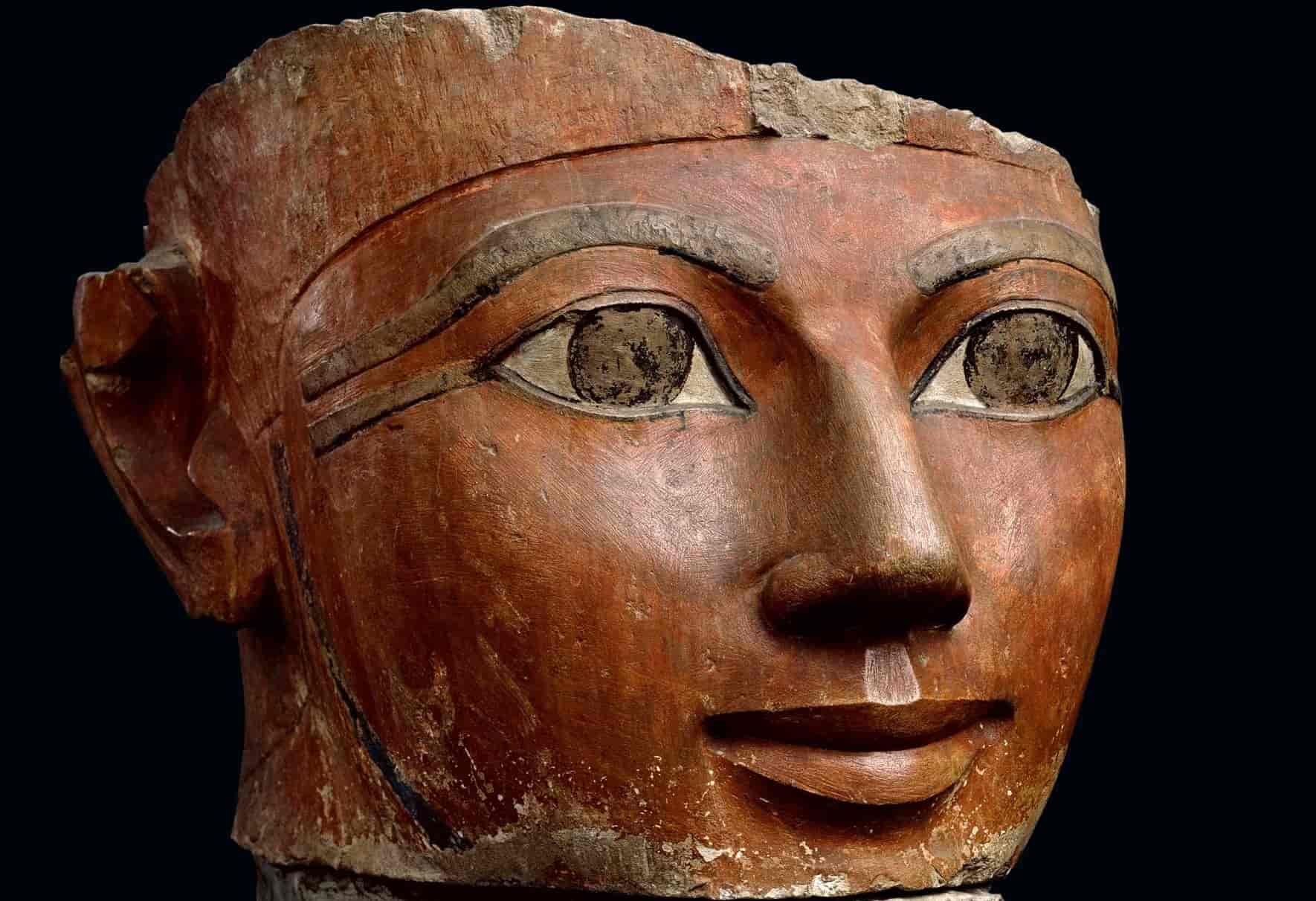
Hatshepsut: the evil polytheist who invented the concept of ‘Theogamy’ in order to justify the usurpation of throne and her immoral and illegal rule
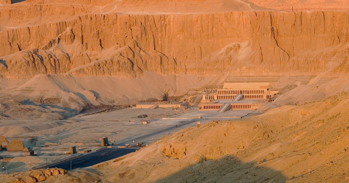
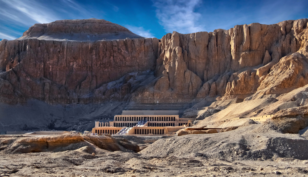
Hatshepsut’s mortuary temple at Deir al Bahari, Luxor West
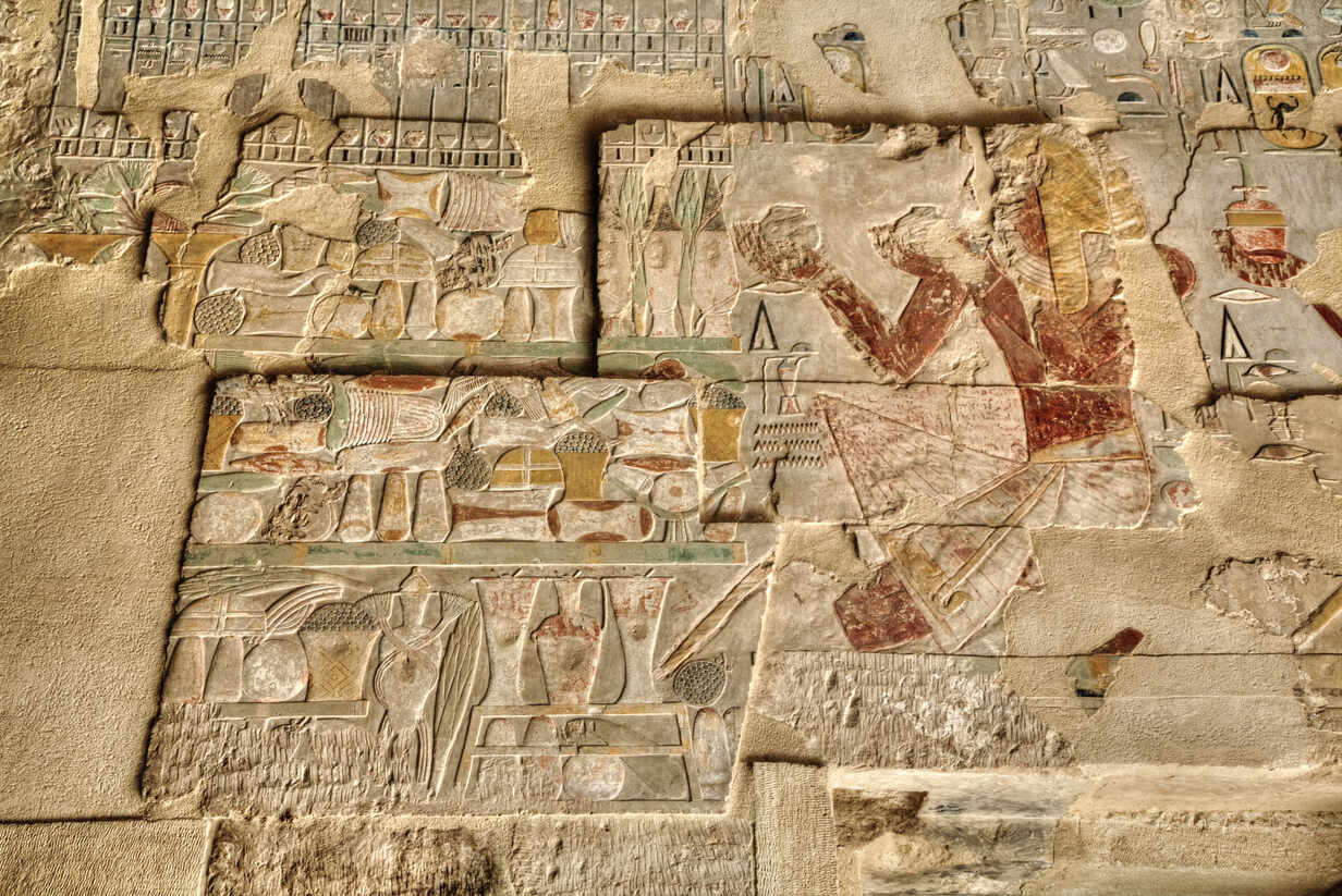
Making offerings to Amun: Hatshepsut’s mortuary temple at Deir el-Bahari
Offerings made to Amun
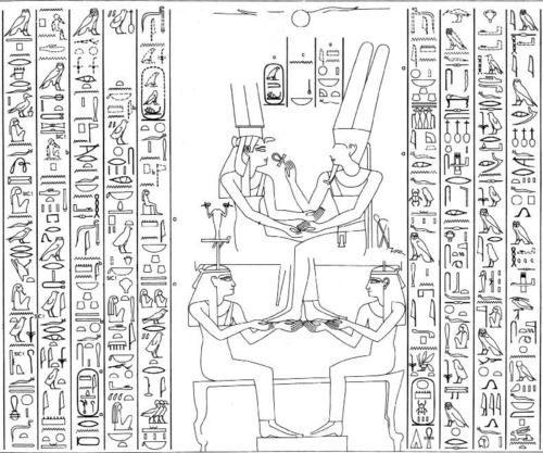
Amun and Ahmose sitting opposite each other in heaven, which is symbolized by two female divinities supporting them; Amun holds the Ankh to Ahmose’s nose and mouth so that she can breathe in the divine essence and conceive the god’s child.
Deir el Bahari textual evidence for the Theogamy:
– the inscription claims that Amun ‘prophesized the birth of Hatshepsut at a council of the gods;
– Amun disguised as Thutmose I and visited Queen Ahmose; the inscription reads (paragraph 196):
“Utterance of Amun-Re, lord of Thebes, presider over Karnak: He made his form like the majesty of this husband, the King Aa Kheper Ka Ra (Thutmose I’s throne name). He found her as she slept in the beauty of her palace. She waked at the fragrance of the god, which she smelled in the presence of his Majesty. He went to her immediately, coivit cum ea (lit. ‘had sex with her’), he imposed his desire upon her, he caused that she should see him in his form of a god. When he came before her, she rejoiced at the sight of his beauty, his love passed into her limbs, which the fragrance of the god flooded; all his odors were from Punt”;
– the queen is then informed by Amun that she has conceived a daughter by him; the inscription reads (paragraph 198):
“Utterance of Amun, Lord of the Two Lands, before her: “Khnemet-Amun-Hatshepsut (her full birth name: ‘United with Amun, the Foremost of Ladies’) shall be the name of this my daughter, whom I have placed in thy body, this saying which comes out of thy mouth. She shall exercise the excellent kingship in this whole land. My soul is hers, my bounty is hers, my crown is hers, that she may rule the Two Lands, that she may lead all the living … “;
– Amun instructs the god Khnum, who was thought to be the creator of flesh, to make the baby and its Ka on his potter’s wheel. The reliefs show Khnum being helped by his consort divinity, the frog-headed Hekt;
– the royal baby and its Ka are depicted in the likeness of a boy, complete with male genitalia;
– the instruction text reads (paragraph 200):
“Utterance of Amun, presider over Karnak: “Go, to make her, together with her Ka, from these limbs which are in me; go, to fashion her better than all gods; shape for me, this my daughter, whom I have begotten. I have given to her all life and satisfaction, all stability, all joy of heart from me, all offerings, and all bread, like Re, forever”;
– Queen Ahmose was led off by Khnum and Hekt to give birth; she was attended by Bes and Taweret (the hippopotamus-like divinity that protected childbirth);
– the newborn child was given the symbols of life, power and protection, before being presented to her ‘father’ Amun;
Complete English translation of the reliefs: https://www.u.arizona.edu/~afutrell/w%20civ%2002/birthofhat.html
All five Pharaonic names of Thutmose I and Hatshepsut:
https://pharaoh.se/pharaoh/Thutmose-I
https://pharaoh.se/pharaoh/Hatshepsut
Thutmose III depicted on the 7th pylon of the Amun temple at Karnak, smiting enemies
Thutmose III holding a hedj Club and a sekhem scepter, while standing before two obelisks

Thutmose III wearing the atef crown
The ‘tekhen waty’ (unique obelisk) of Thutmose III was transported to Rome, following a decision made by Emperor Constantine I and materialized by Constantius II in 357 CE. Initially, it stood in Circus Maximus; it then collapsed and it was covered by the mud (in the 5th c.). Finally, it was restored in the 1580s and erected in front of the Archbasilica of St. John Lateran with the addition of a cross atop of it. The acquisition of the obelisks erected by Thutmose III was of particularly notable interest for the religious authorities of Roman and Constantinopolitan Christianity; Theodosius ordered the shipment (390 CE) of another obelisk, which was initially built by Thutmose III, to Constantinople; it was installed in the Hippodrome.
Amenhotep II shown at the Temple of Amada, 180 km south of Aswan, near the Lake Nasser
Thutmose IV wearing the blue crown; grandfather of Akhenaten, he actively supported the rise of the monotheistic solar ideology, therefore receiving many unjust comments and insults by the fanatic priests of Amun – something that his grandson explicitly stated, denounced and regretted.

The famous Dream Stele of Thutmose IV; the pharaoh built the monument after having slept between the paws of the Great Sphinx; the text shows an extraordinary increase in terms of solar cult and spirituality.
Amenhotep III, predecessor and father of Akhenaten
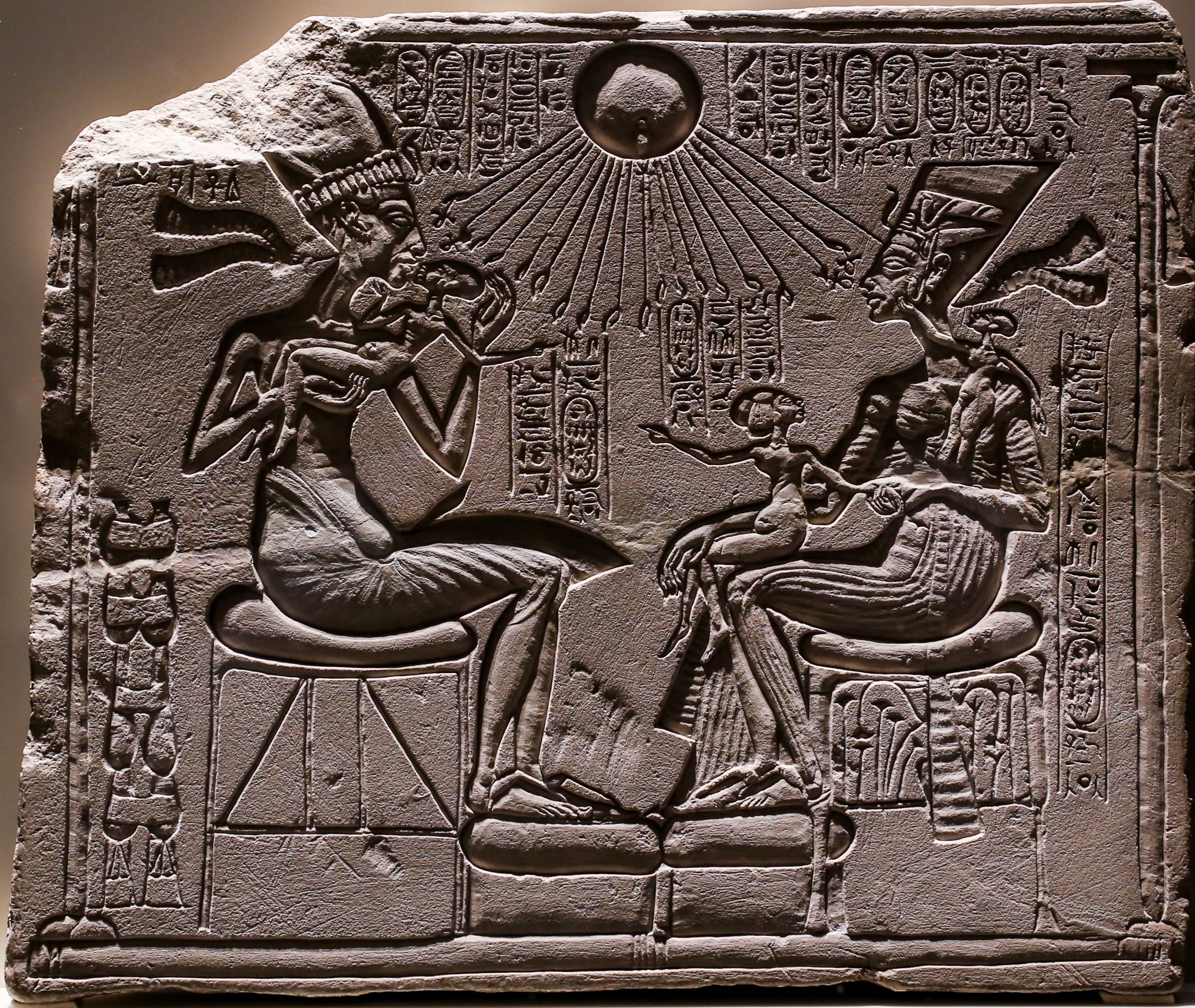
Akhenaten and Nefertiti with their children under the blessings of Aten whose benediction takes the form of solar rays ending in hands that hold Ankh, the symbol of spiritual life and potency
Akhenaten depicted as a sphinx on a relief unearthed in his capital Akhetaton, i.e. the modern Tell el Amarna (or Amarna)
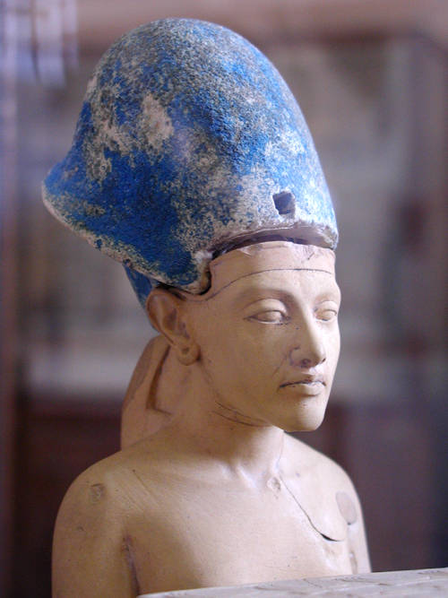
Akhenaten wearing the Egyptian Blue Crown of War
The legendary statue of Akhenaten that triggered endless scholarly discussions about the (radically different from the Classical Ancient Egyptian Art) Amarna Naturalism and the eventuality of particular health problems of the great monotheist pharaoh
Typical boundary stele from Akhetaton / Amarna, the monotheistic capital of Akhenaten in Middle Egypt (not far from Al Minia)
Akhetaton / Amarna, the Temple of Aten
Akhetaton / Amarna, the northern palace
Akhetaton/Amarna, diagram and reconstruction of the royal quarters
Akhetaton/Amarna: general view
The typical practice of the days of Akhenaten: the Amun name was erased from wherever it was written. Stela of Djeserka (full name: Djeserkareseneb / Djeser-ka-re-seneb), a temple doorkeeper at Karnak, Thebes
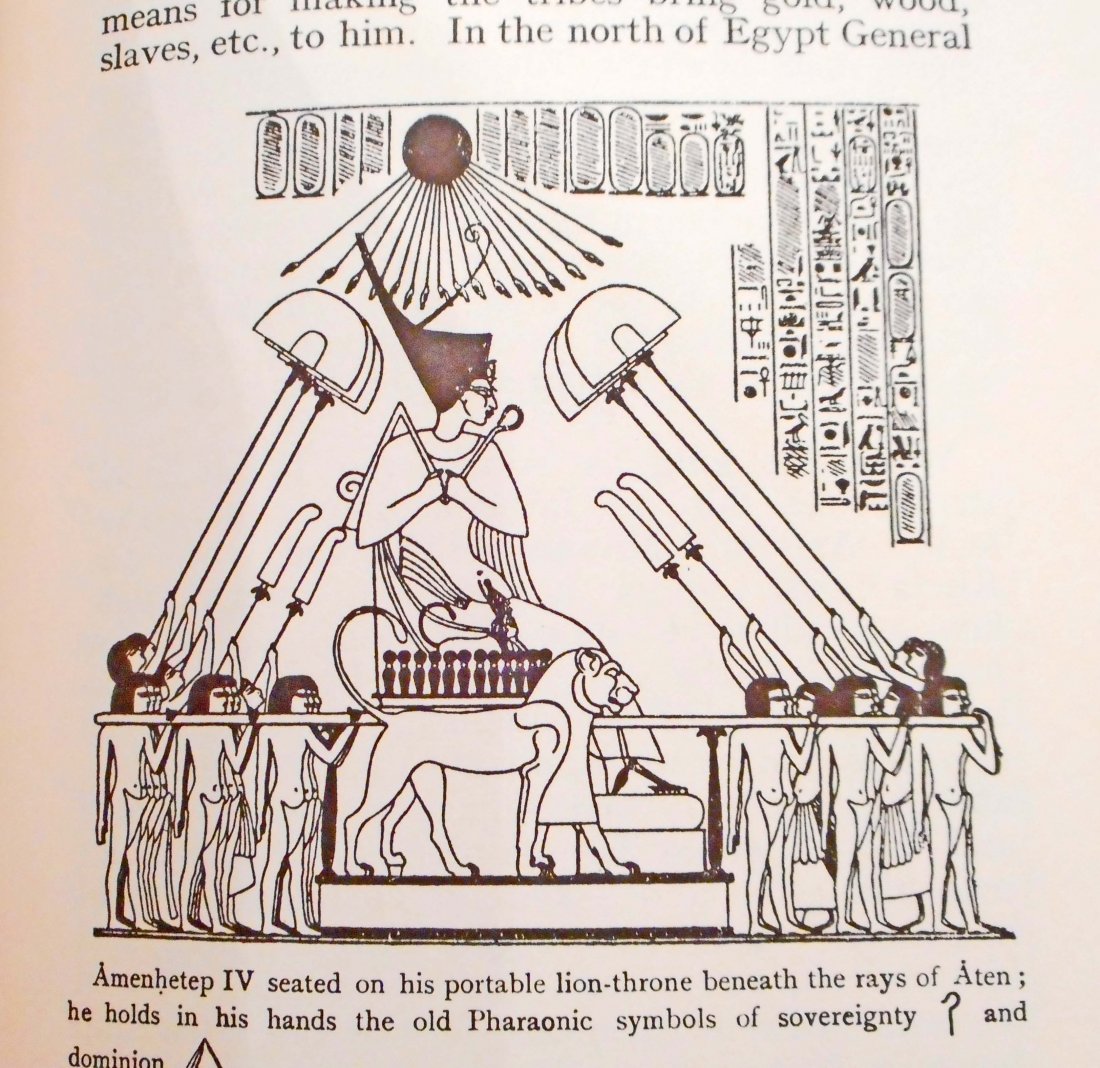
Design from the wall paintings of the tomb of Meryre II, royal scribe, steward, and overseer of the two treasuries, at Akhetaton/Amarna; in the royal year 12, Akhenaten is depicted as receiving tributes, while sitting on the throne and being blessed by the rays of Aten. About: https://en.wikipedia.org/wiki/Meryre_II and https://open.library.ubc.ca/cIRcle/collections/ubccommunityandpartnerspublicati/52387/items/1.0422133
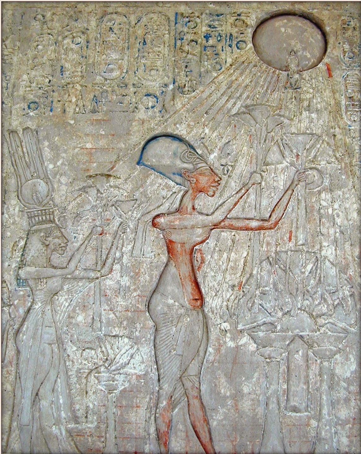
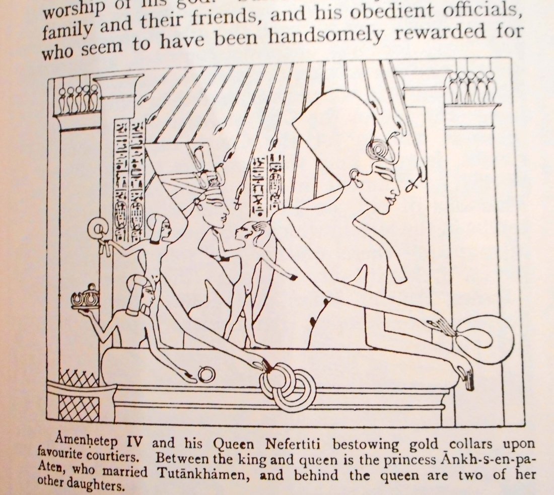
Akhenaten and Nefertiti make offerings to Aten; from a limestone stela in the Museum of Cairo
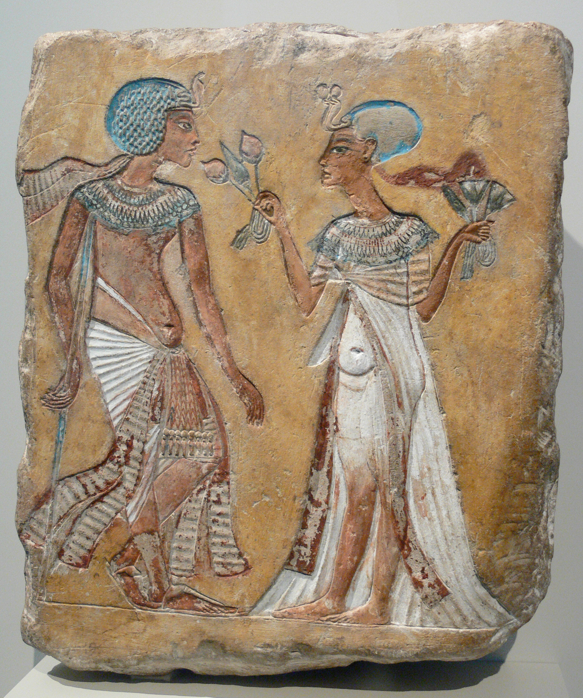
The successors of Akhenaten proved to be unable to outmaneuver the Amun polytheist conspiracy against the monotheist state that was based in Akhetaten; relief with an unidentified royal couple that may very well be either Smenkhkare & Meritaten (Akhenaten’s first successor and his wife) or Tutankhamun & Ankhesenamun
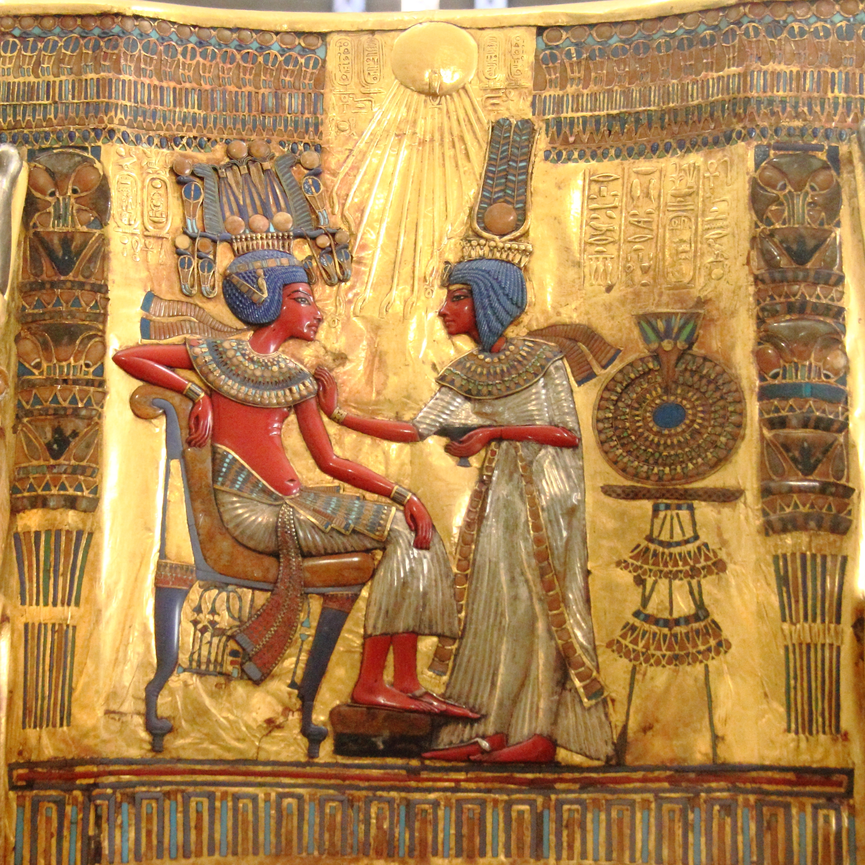
Backing of the golden throne of Tutankhamun; the pharaoh and his wife Ankhesenamun are depicted as blessed by the rays of Aten, before the Amun polytheist restoration; at the time, they were respectively named Tutankhaten and Ankhes-enpa-Aten
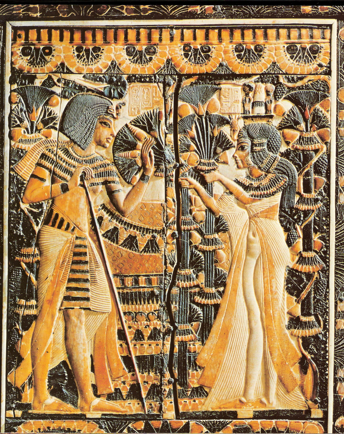
Tutankhamun and Ankhesenamun
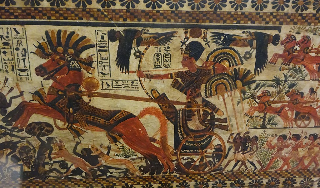
Tutankhamun depicted on a chariot, participating in a military campaign
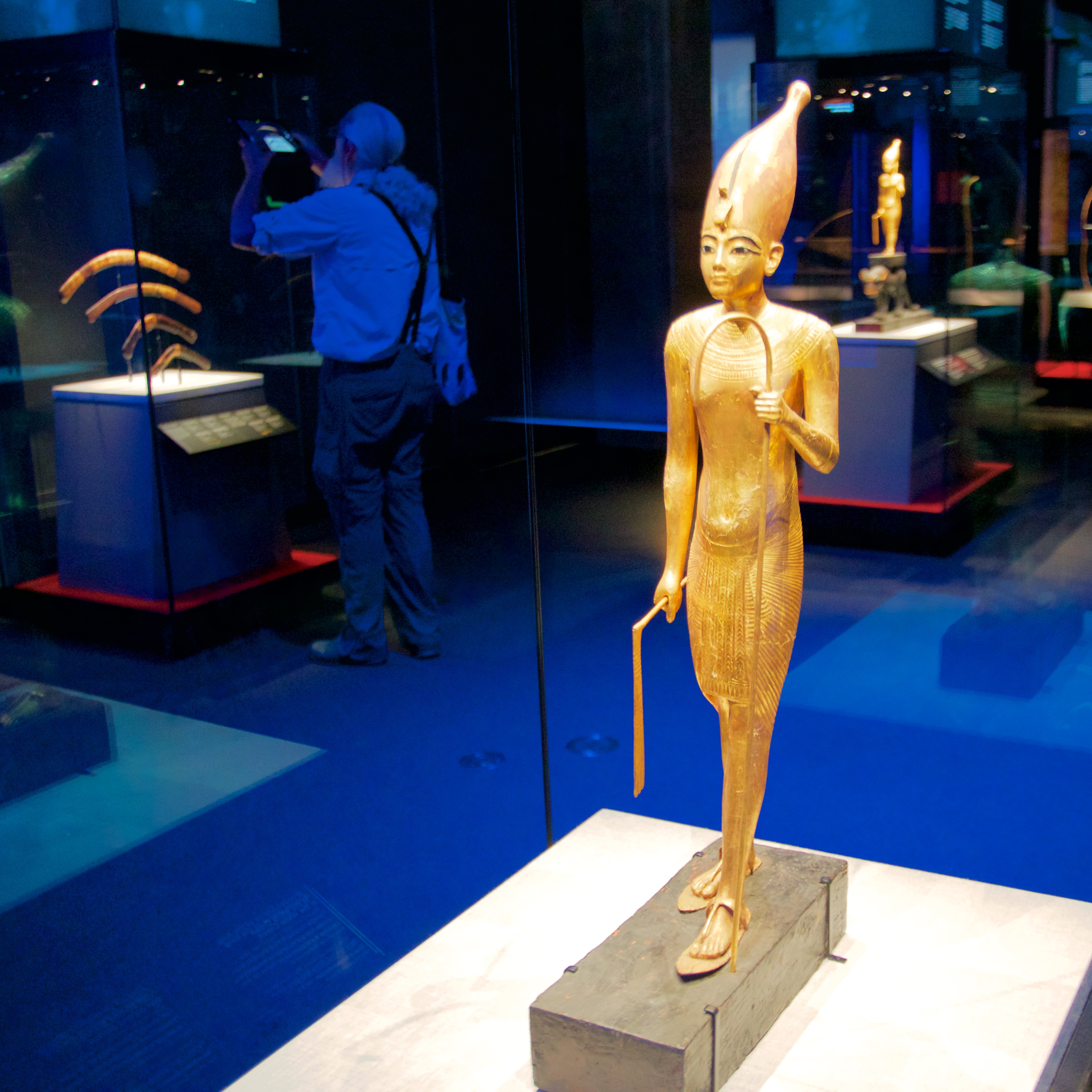
Tutankhamun holding the Pharaonic insignia
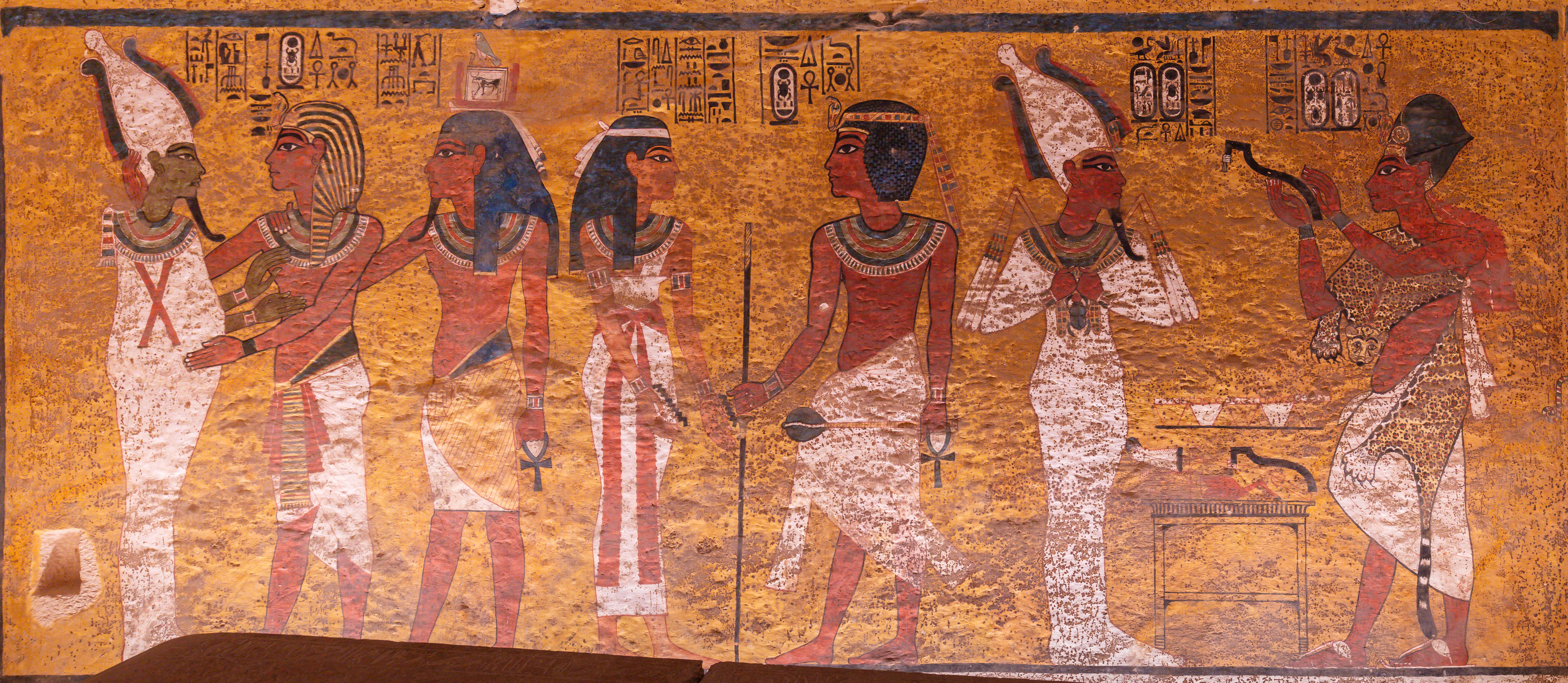
From a wall painting of the burial chamber of KV62 (the tomb of Tutankhamun): Tutankhamun and his Ka (standing behind him) embrace Osiris (in the left part of the picture); the deceased pharaoh greets Nut (in the central part); on the right side, the treacherous polytheist priest of Amun Ay performs the ceremony of the Opening of the Mouth for the dead of the eventually assassinated Tutankhamun, who is depicted as Osiris. Ay had first forced Tutankhamun to restore the polytheistic religion of the Theban Trinity and then, after the young pharaoh’s death or assassination, he was proclaimed as pharaoh. About the Theban tombs: https://en.wikipedia.org/wiki/List_of_Theban_tombs / https://en.wikipedia.org/wiki/Theban_Necropolis / https://en.wikipedia.org/wiki/Theban_Necropolis
Ay’s royal names on a faience plate
Ay’s main ally against the monotheist state proclaimed by Akhenaten was Horemheb, an ignorant and fanatic soldier of socially low status; with the support of the polytheist clergy of Amun, he succeeded Ay and he ruled Egypt, launching a White Terror against the monotheists and dividing the country irrevocably. With the divisive and tyrannical rule of Horemheb, we observe in Egypt conditions similar to those described in the Bible, involving oppression, persecution, hatred and ignominy. Here, on the 10th pylon of the temple of Amun in Karnak, he is depicted as making offerings to Amun.
Wepwawet wolf-god of war & death, giving scepters to Seti I; relief from Seti I’s temple at Abedju (Abydos); second pharaoh of the 19th dynasty, Seti I was a particularly cruel pharaoh, who proved to be very heinous against the monotheists.
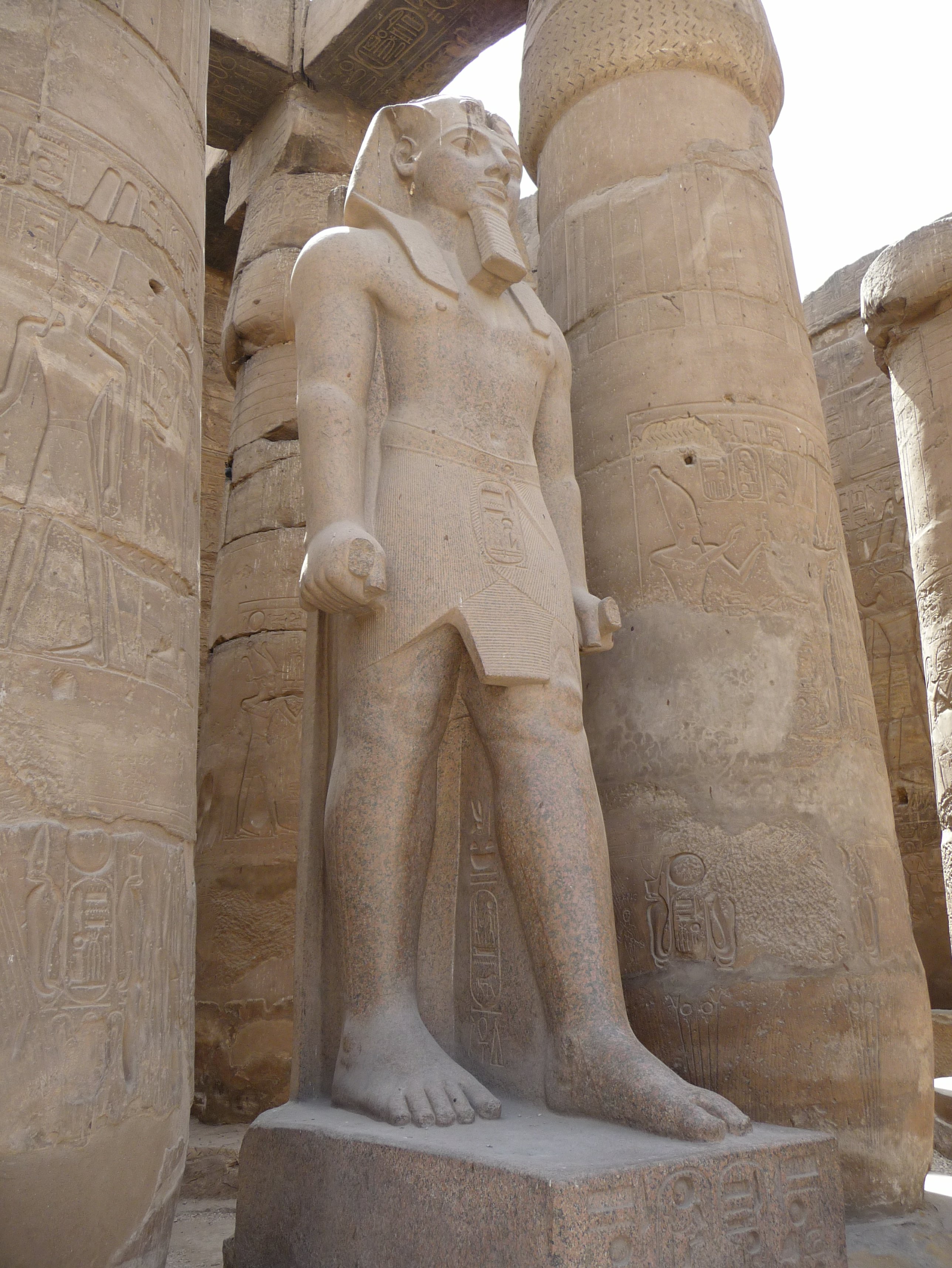
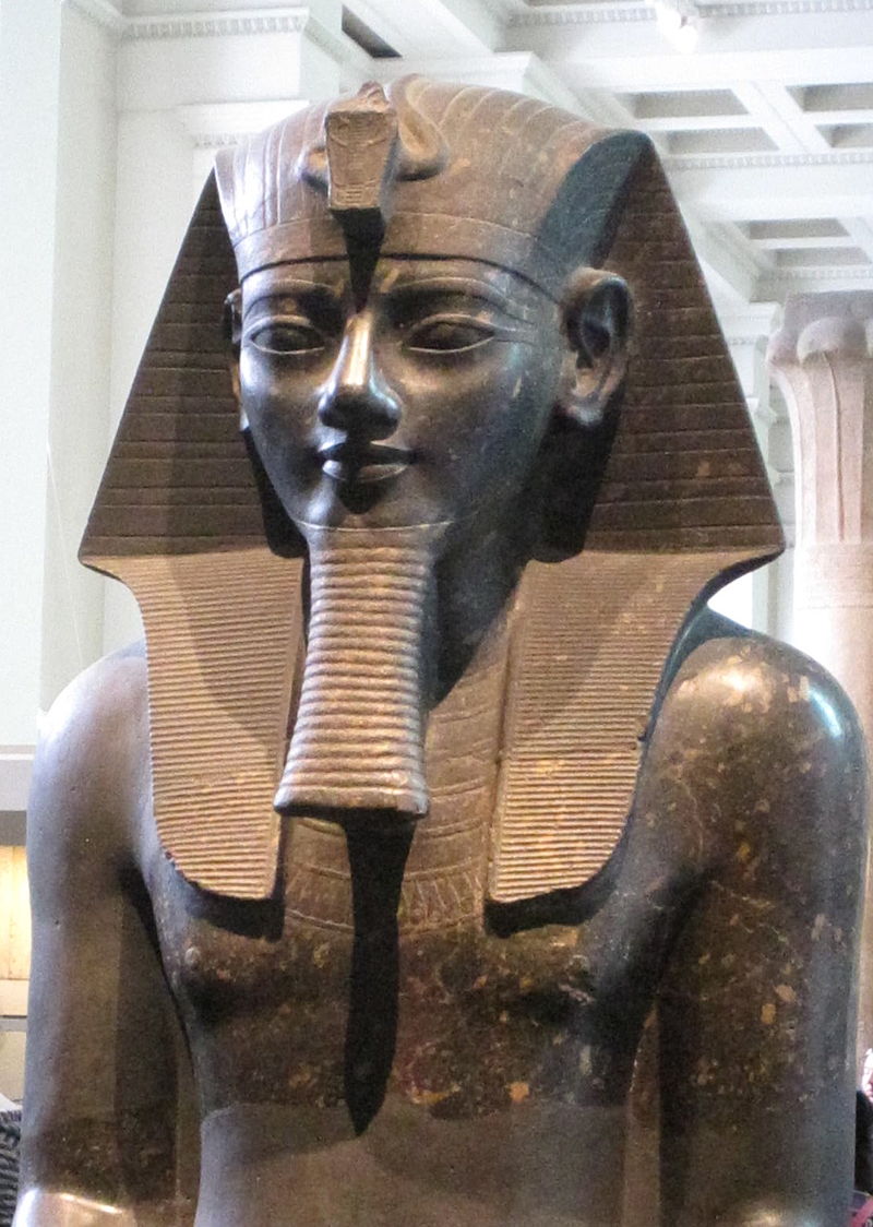
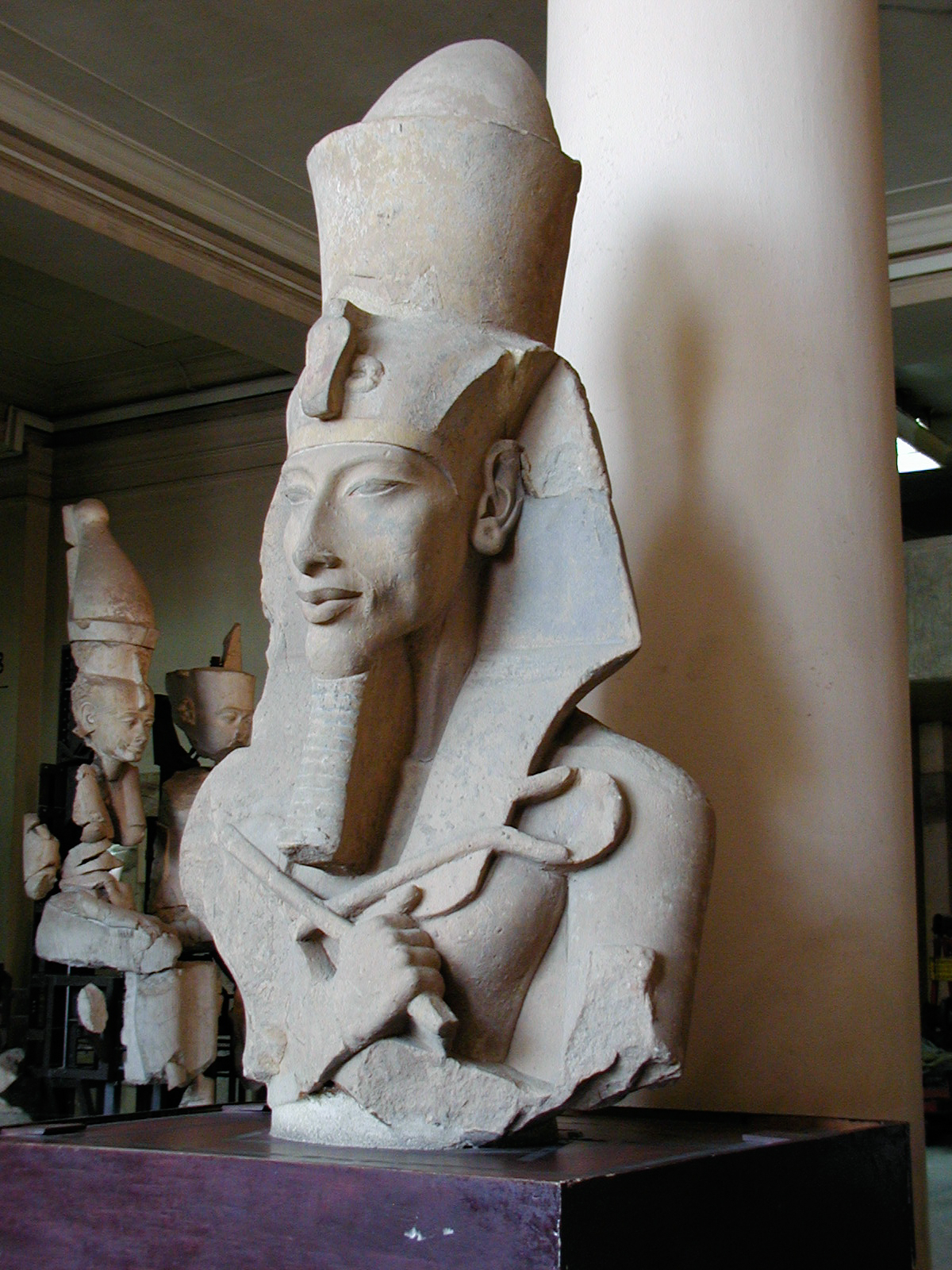
Ramesses II seems to have been a monotheist ruler who reigned over Kemet in an alliance with part of the then powerful polytheist priesthood. Enormous statue of Ramesses II from the first peristyle court of the Amun temple at Luxor; Ramesses II was the most important ruler of the 19th dynasty and one of the longest reigning monarchs in World History. He undertook an excessive project of constructions that absorbed all of the country’s resources and exhausted the population; this was his method of keeping the people busy, unfree and unable to react to the polytheist regime. He is the first of the two pharaohs related to the Exodus narrative.

Diorite statue of Ramesses II from Thebes, today in the Museo Egizio of Turin
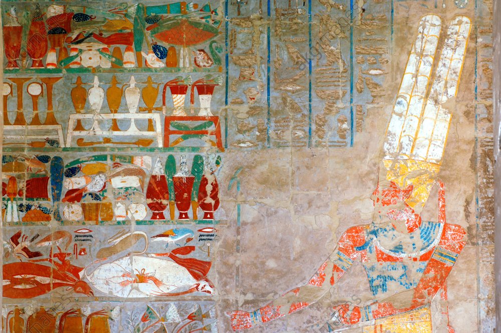
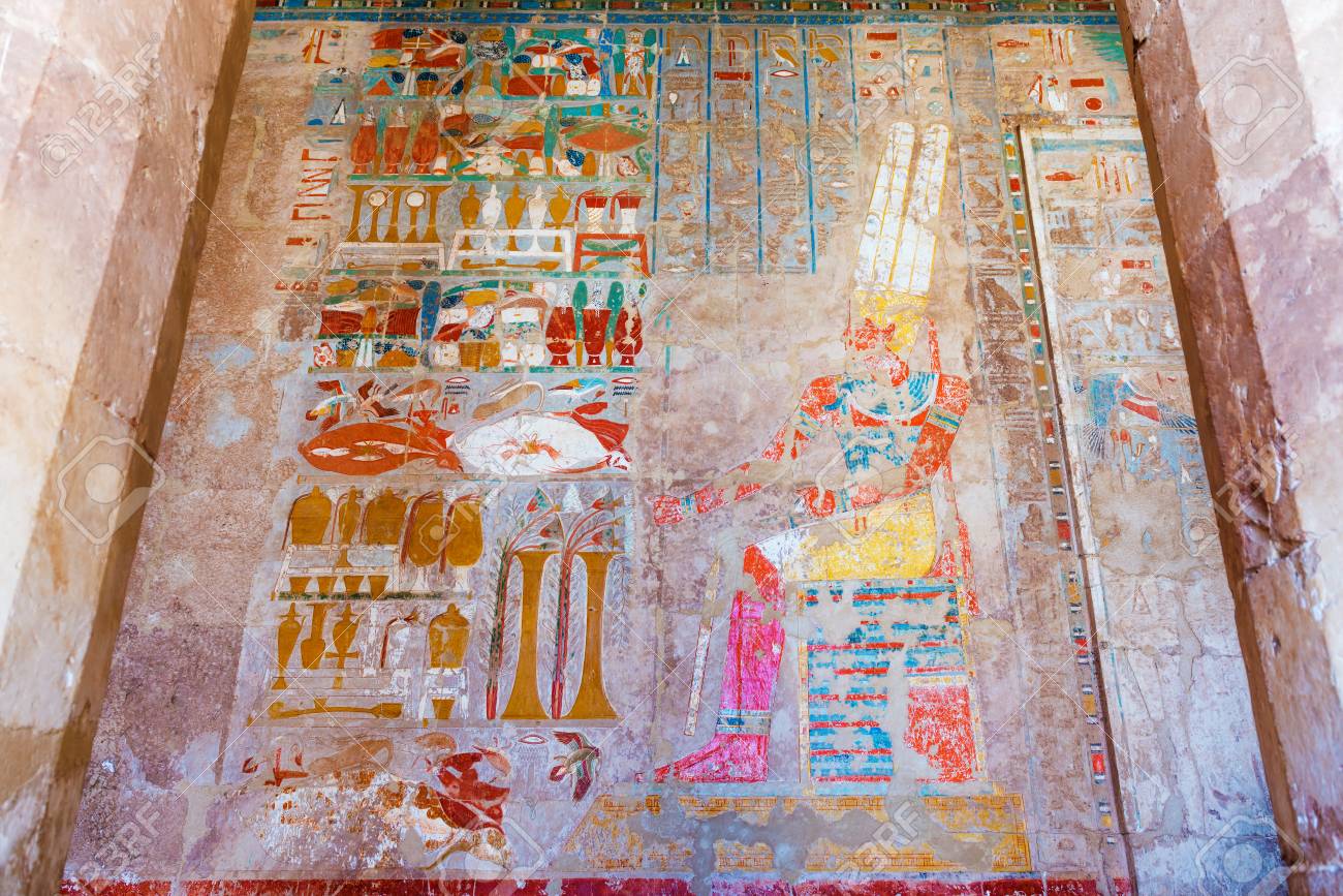
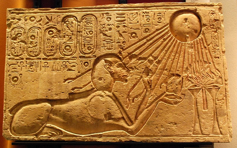
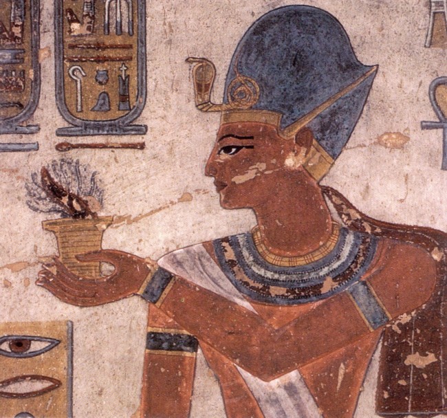
Merenptah offering to Ptah; during his reign, the monotheist Egyptians and the Hebrews left Egypt, crossing the Red Sea

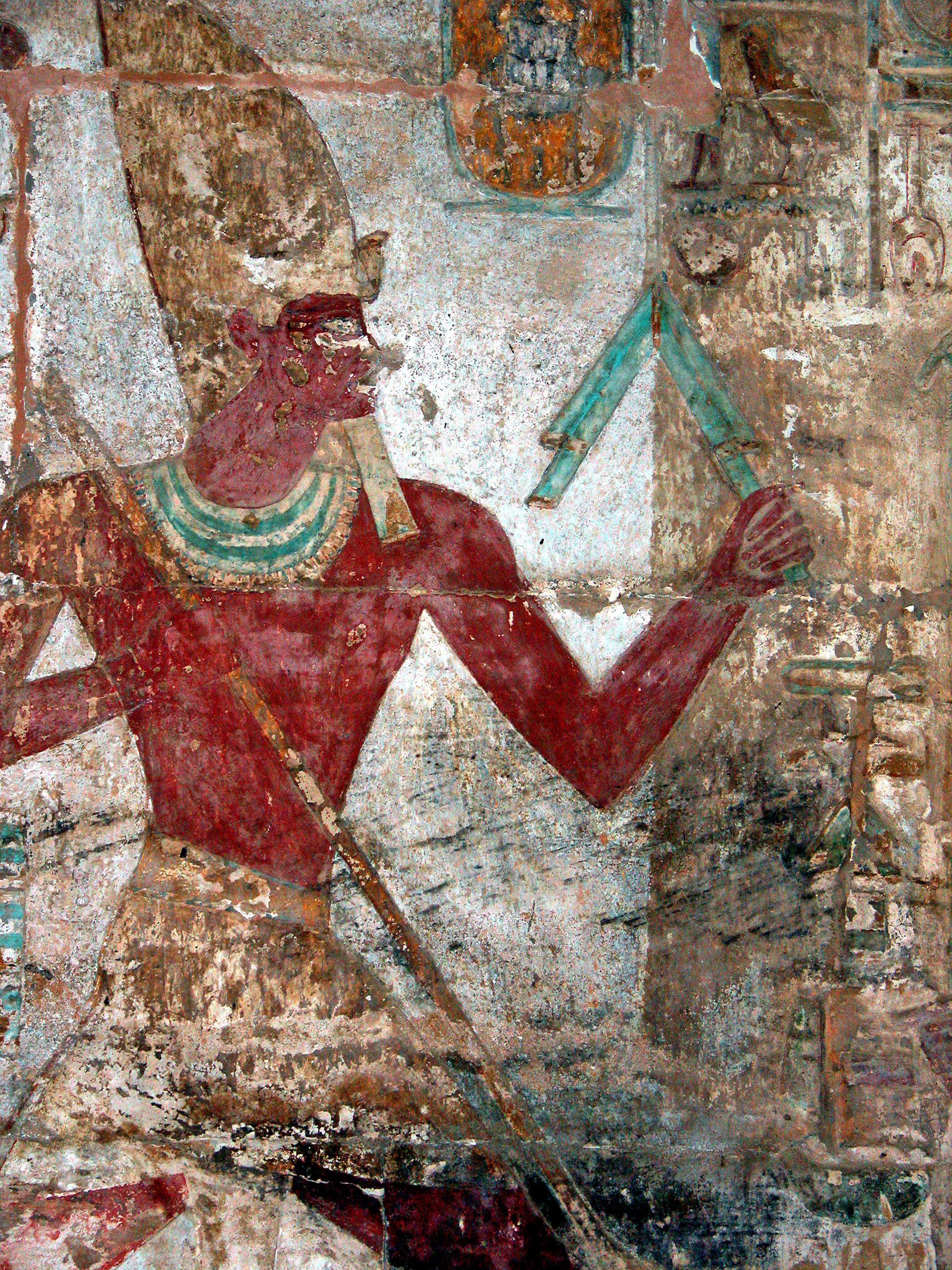
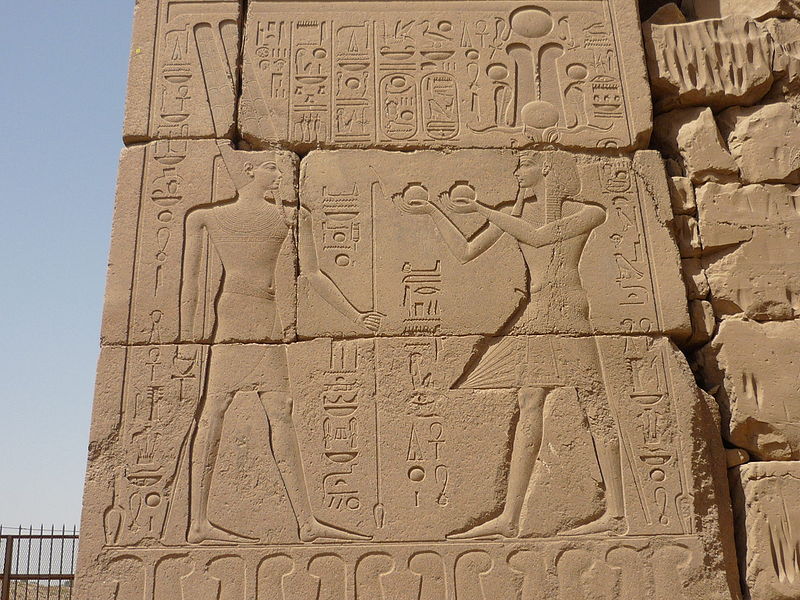
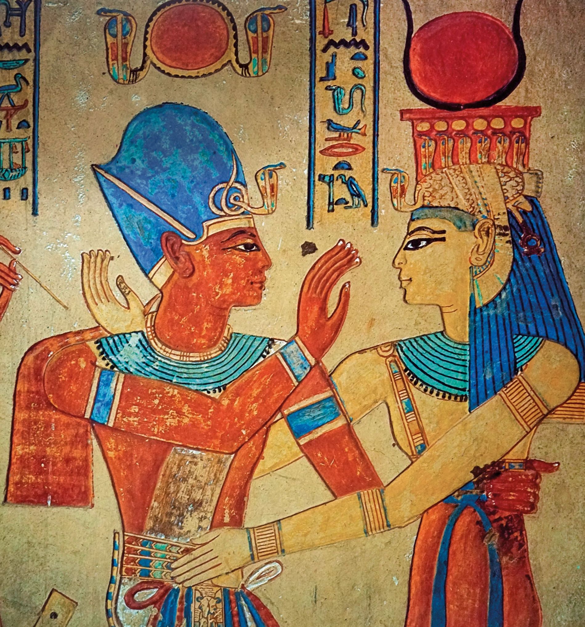
Second ruler of the 20th dynasty, Ramesses III was a staunch monotheist, who did not challenge the religious prevalence of the polytheists; but his reign was filled with exploits that damaged irreversibly the plans of the polytheists to take control over Egypt. In this relief from the Temple of Khonsu at Karnak, Ramesses III makes an offering.
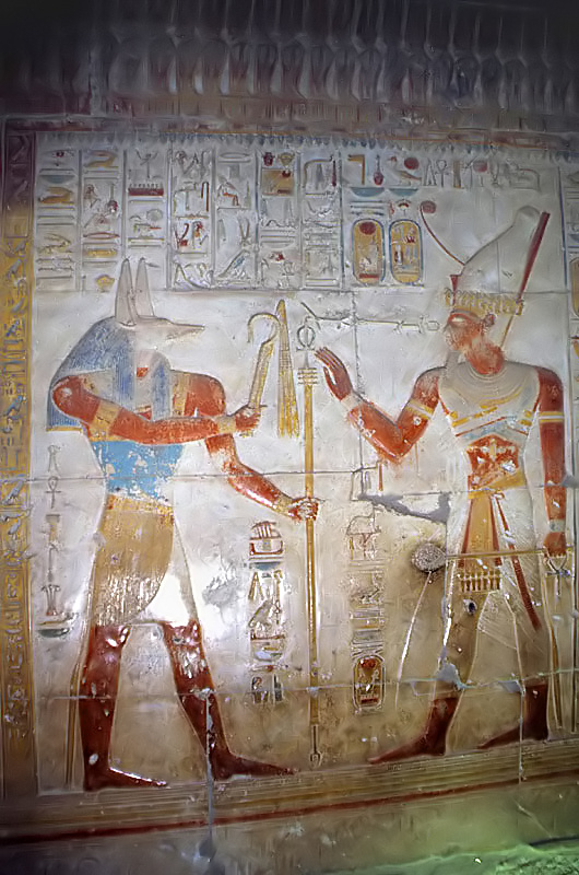
Ramses III offering incense, wall painting from his tomb (KV11) in the Kings Valley, Luxor West
Ramesses III makes an oath to Isis; from the tomb of the Prince Amunher khepeshef
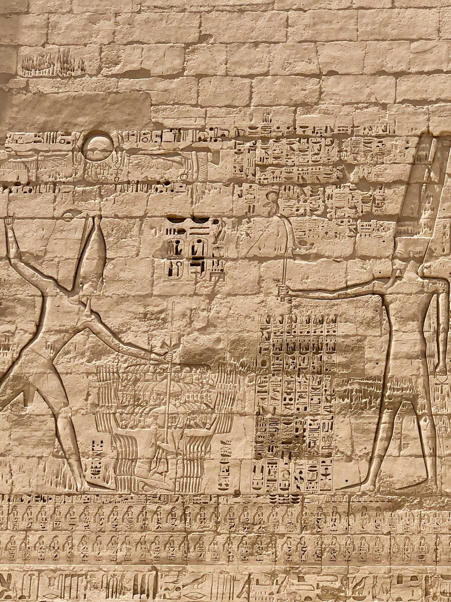
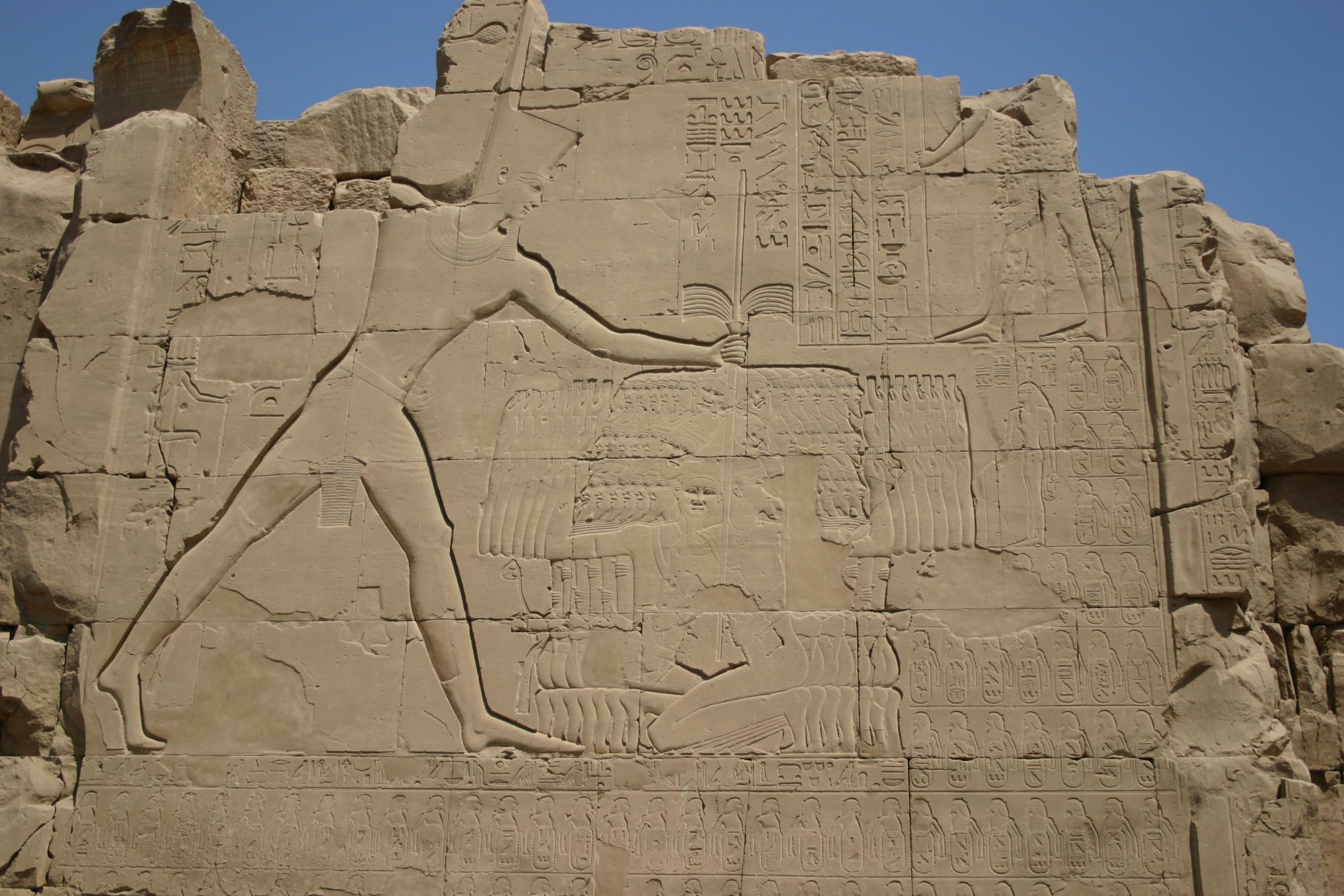
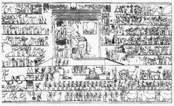
The three victories of Ramesses III against the Sea Peoples was Egypt’s greatest gift to Mankind and foremost contribution to World History. Following these developments, the historical role of Egypt had already been completed. From the pylon of Ramesses III’s mortuary temple at Medinet Habu (Luxor West): Ramesses III presents his victory over the Sea Peoples to Amun.
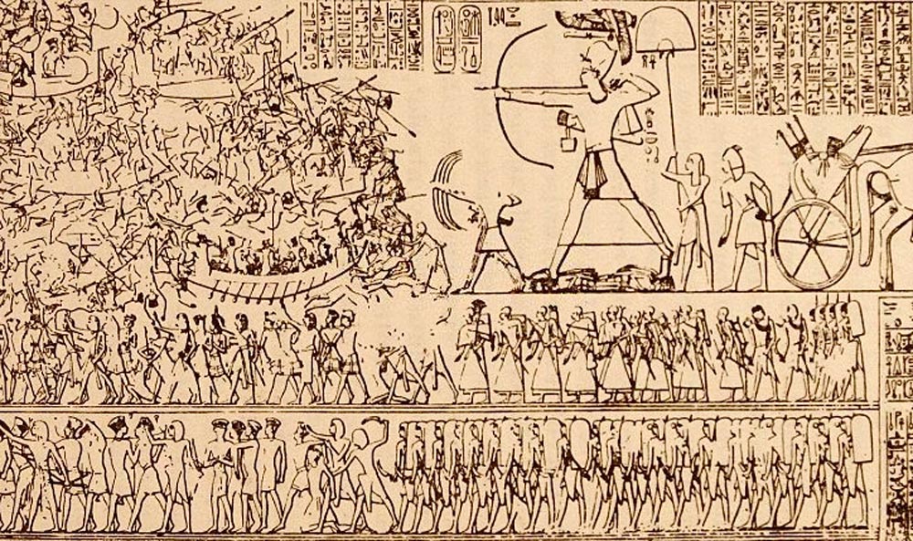
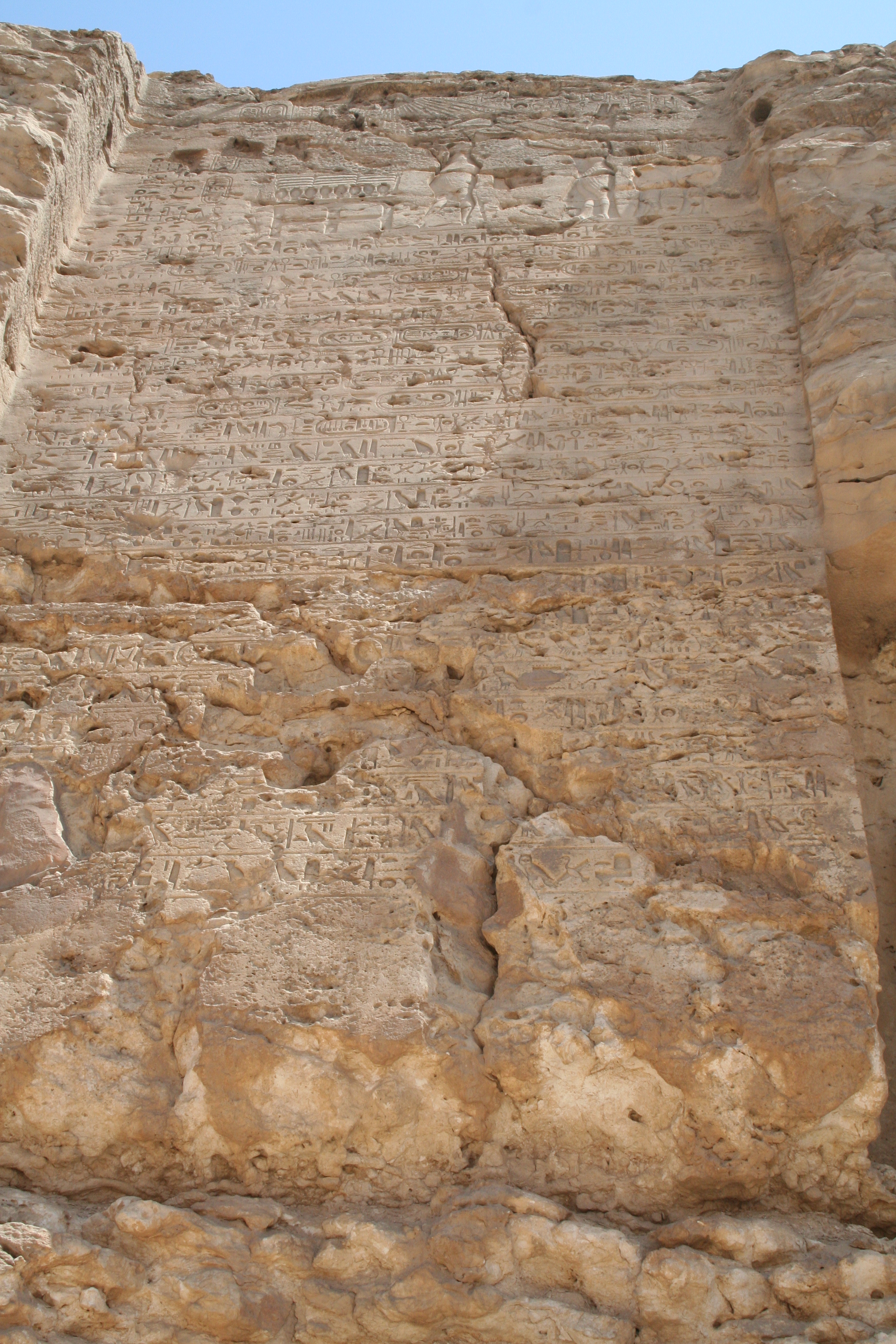
Design of the reliefs and the texts of the Northern Wall (outer side) of Ramesses III’s mortuary temple at Medinet Habu: Ramses III in the Battle of Djahy (one of the battles against the Sea Peoples)
From the Medinet Habu reliefs: severed hands of the defeated Sea Peoples. This was indeed a splendid gift to the civilized world and a most demanded punishment of the incestuous barbarians who intended to plunge the Mankind into lawlessness, non-violence, fornication, sodomy, and polytheism.
———————————————————————————————
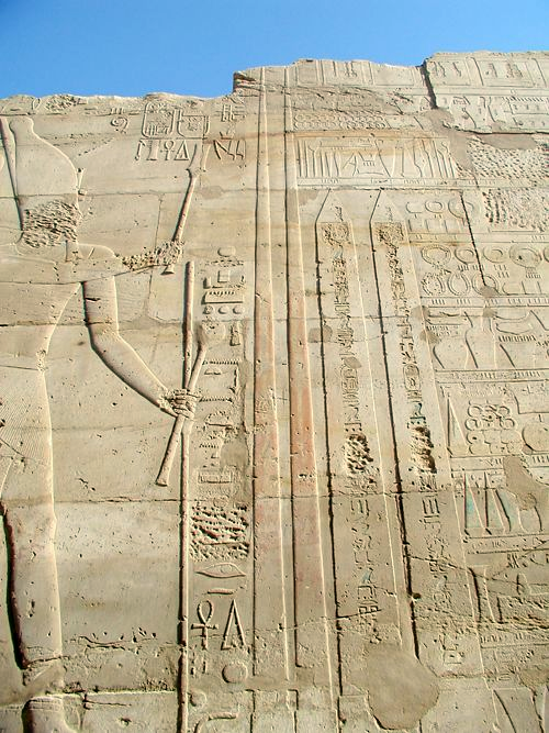
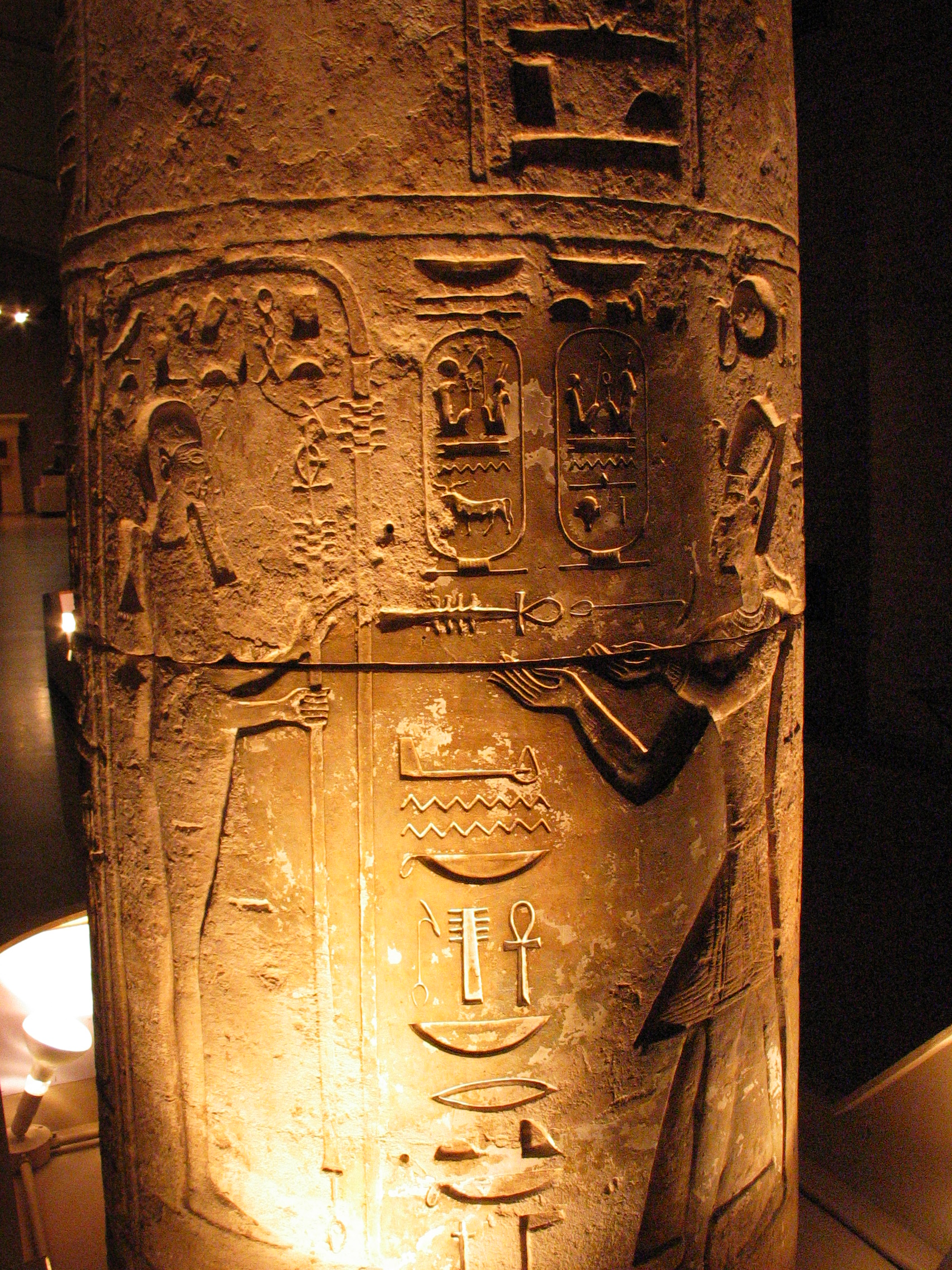
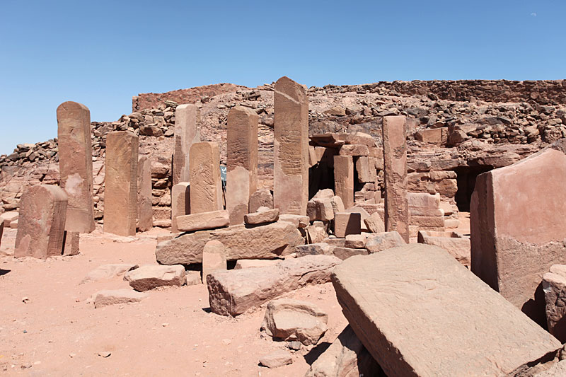
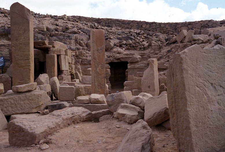
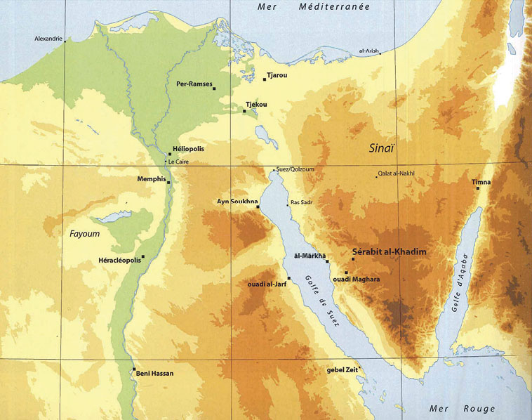
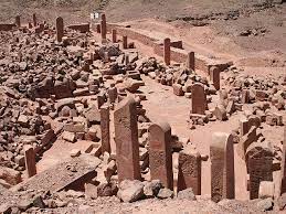
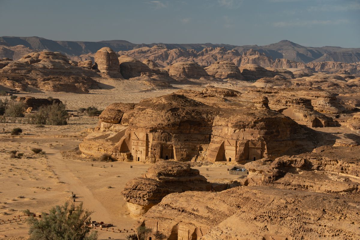
IV. Serabit al Khadim and the Temple of Hathor: a Major Egyptian Site
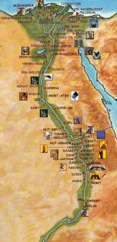
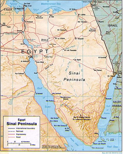
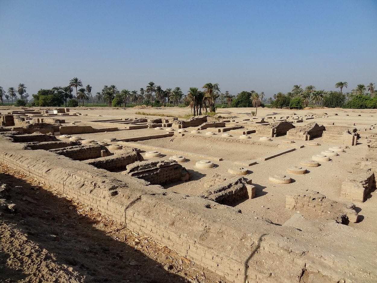
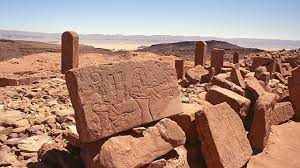
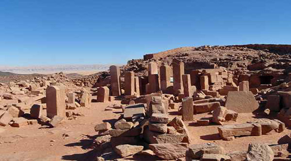
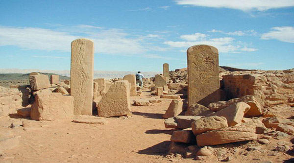
Abu Zanimah is situated at ca. 170 km south of Suez on the western coastland of what we mistakenly call today the ‘Sinai Peninsula’. Reaching this place, one has crossed more than half the distance between Suez and Sharm el Sheikh (290 km), which is the most famous resort in the wider region. Approximately 40 km east of Abu Zanimah is located the major archaeological site in the region, i.e. Serabit al Khadim (سرابيط الخادم/lit. ‘the standing rocks of the servant’).
This appellation concerns the presence of a large number of rock blocks, each of which was called ‘sarbut’, meaning ‘the standing rock’ (‘serabit’ being the plural). The name of the servant, who was associated with them, reflects the statues scattered inside the temple, which represented (or were viewed as) ‘servants’ for the residents of the old. This is how the name came into existence. There are many other important sites and monuments in the wider region, involving fortifications, caves, turquoise mines, smaller temples, and numerous inscriptions.
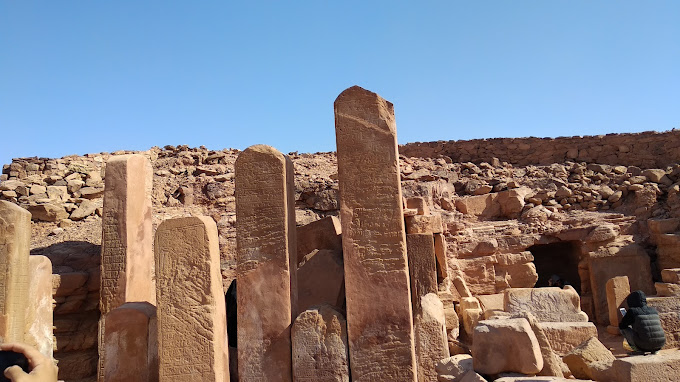
Serabit al Khadim: the Standing Rocks of the Servant


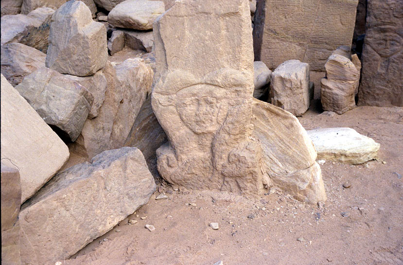
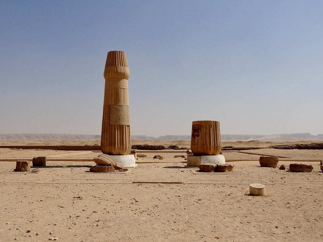
Hathor capital
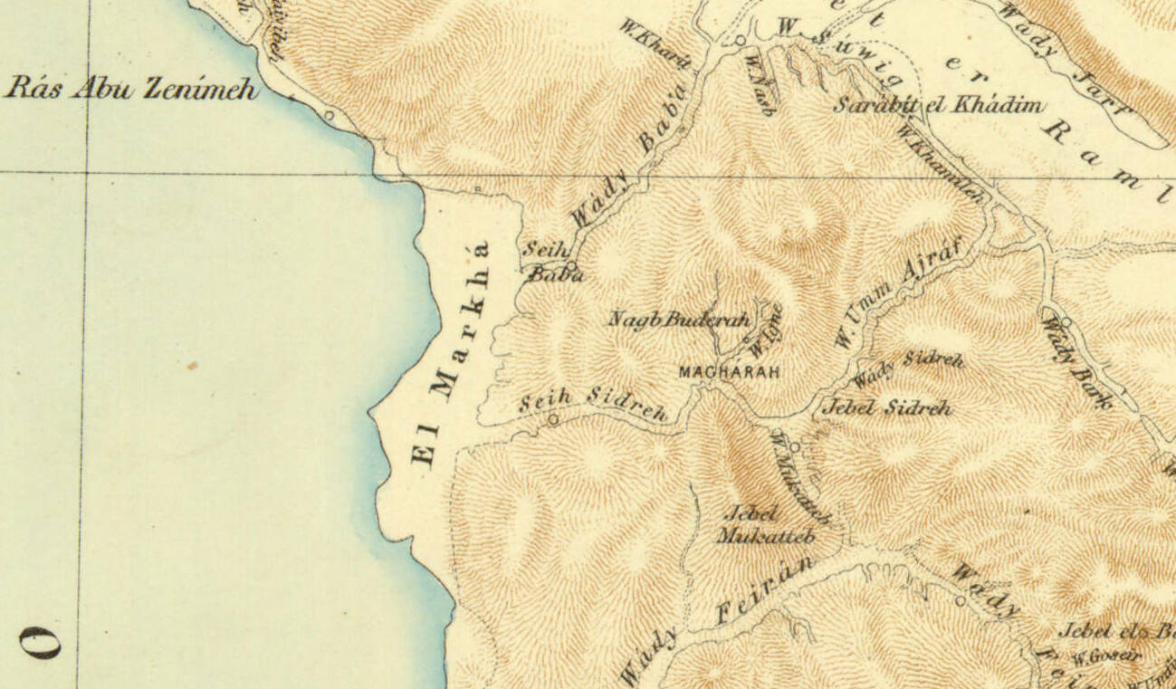
Serabit al Khadim as presented in the Ordnance Survey that was undertaken by Sir John Pakington in 1869; about: https://discovered.ed.ac.uk/discovery/fulldisplay?vid=44UOE_INST:44UOE_VU2&tab=Everything&docid=alma996335823502466&lang=en&context=L&query=creator,exact,Feis,%20Herbert,%201893-1972.
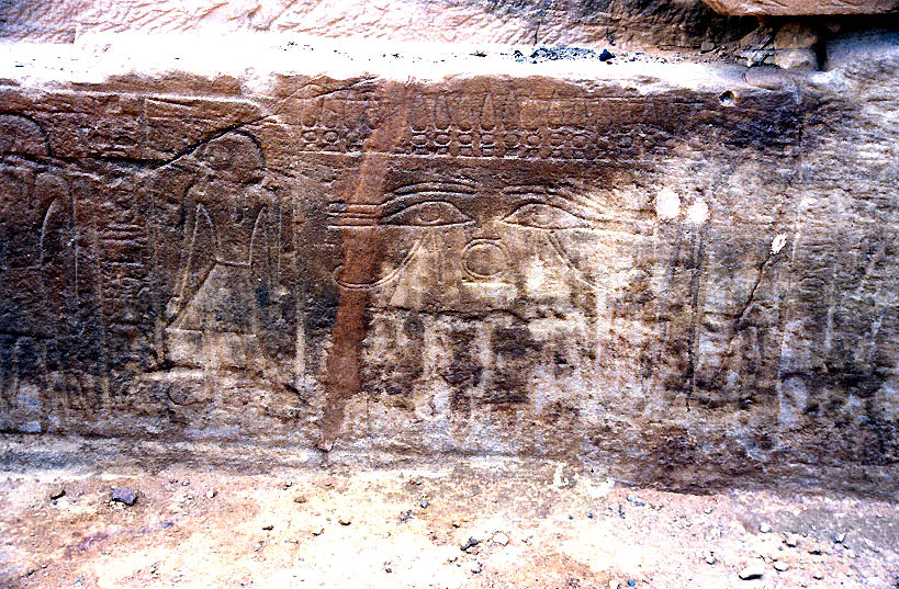
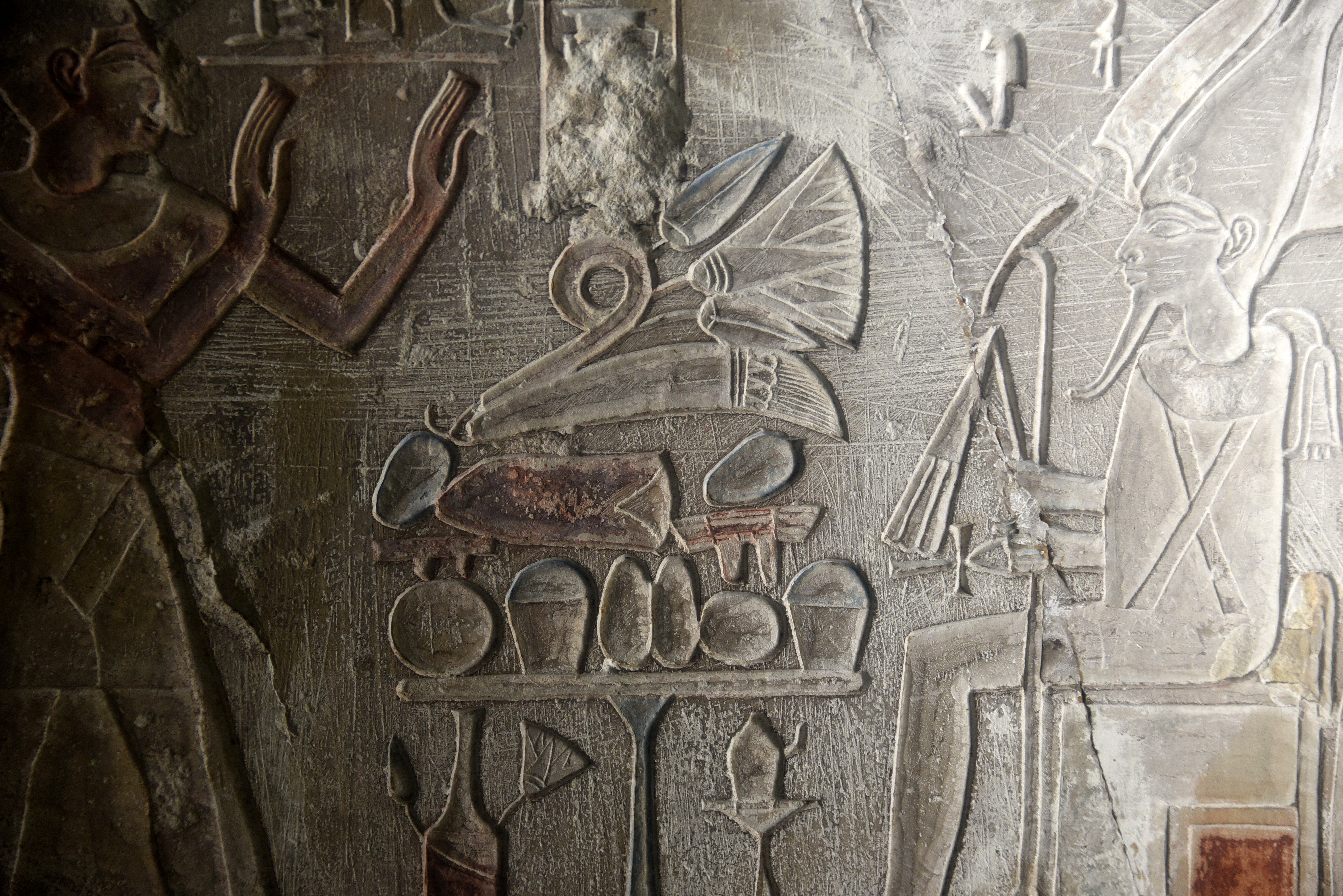
Reliefs and hieroglyphic inscriptions
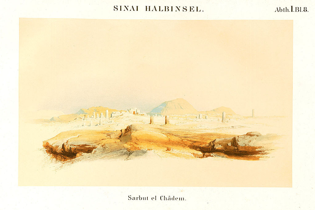
Drawing made during the famous Prussian Expedition to Egypt in 1842-1845; the academic mission was led by the renowned Karl Richard Lepsius, one of the ‘Fathers of Modern Egyptology’. About: https://en.qantara.de/content/egypt-expedition-1842-a-prussian-tour-to-the-land-of-the-pharaohs
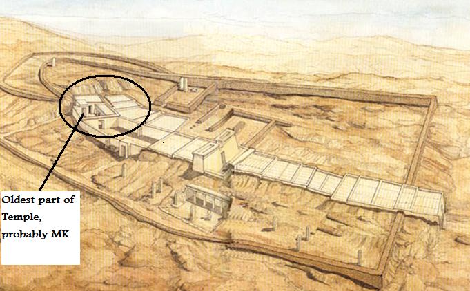
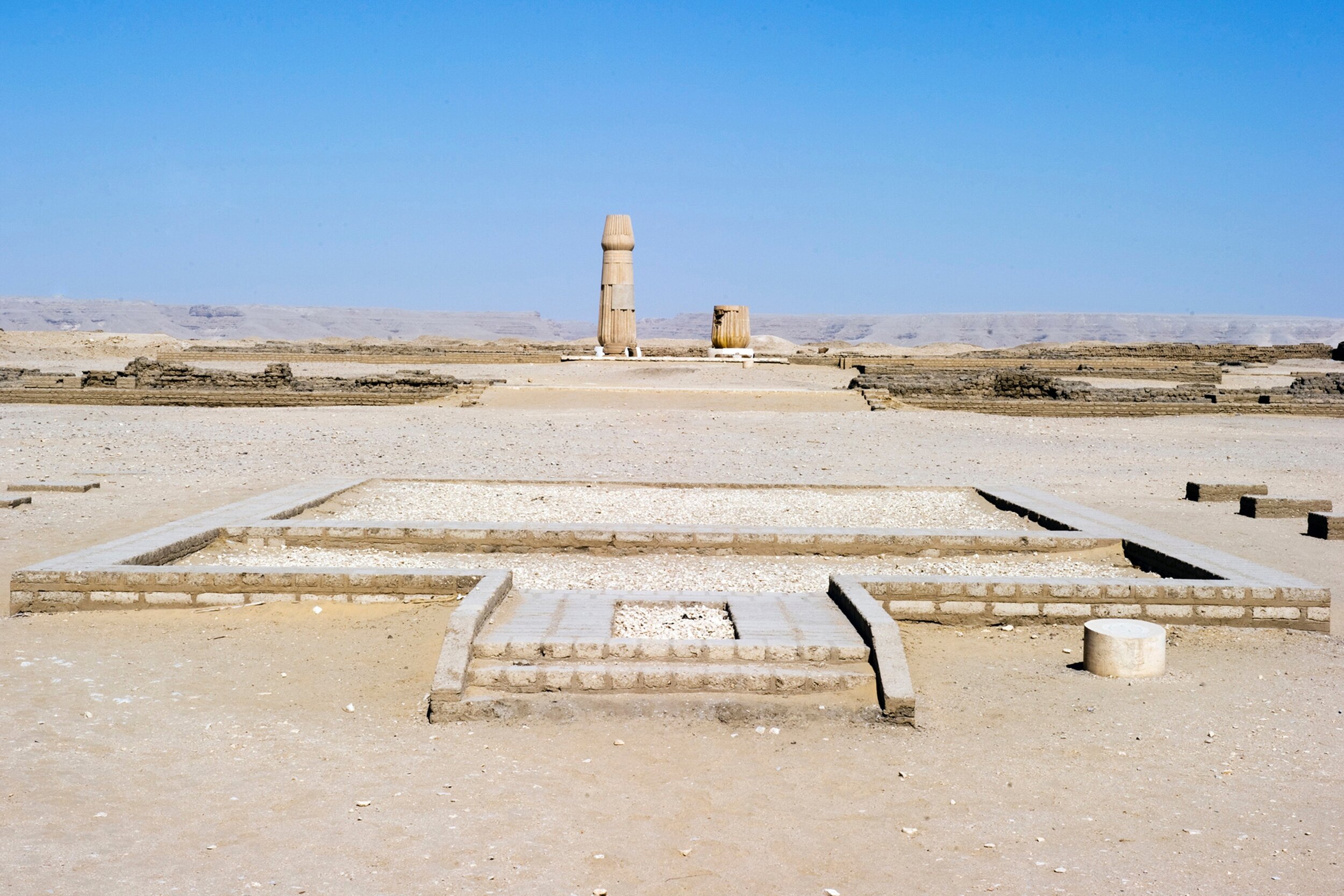
The Hathor temple, a diagram
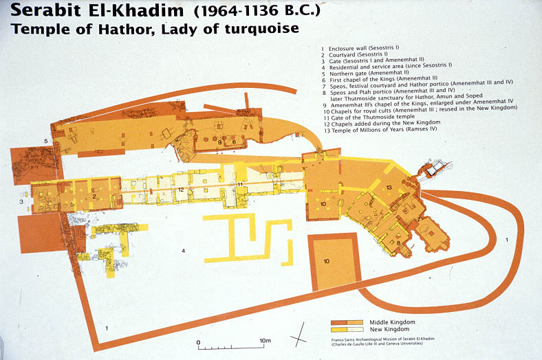
The existence of the great temple of Hathor at Serabit al Khadim demonstrates that this place was a major center of Ancient Egyptian monotheistic cult. The temple was initially excavated by Sir Flinders Petrie in the very first years of the 20th c. and subsequently explored by different groups of archaeologists and epigraphists. The temple dates back to the Middle Kingdom (early 2nd millennium BCE); Hathor was often symbolized as a cow to reflect the aspect of divine fertility, but basically her name means ‘the House of Horus’. For this reason, her cult was regularly associated with that of Isis, who was believed to be ‘Mother’ to Horus (the Ancient Egyptian concept of Messiah), according to the Iwnw Heliopolitan doctrine of Ennead, i.e. one of the staunchest monotheist faiths in Ancient Egypt. As a matter of fact, the two divine hypostases (Isis and Hathor) were often identified with one another. About:
https://www.mindat.org/loc-228179.html
https://upload.wikimedia.org/wikipedia/commons/4/49/Ancient_Egypt_map-hiero.svg
https://www.touregypt.net/featurestories/serabit.htm
https://www.lonelyplanet.com/egypt/sinai/attractions/serabit-al-khadim/a/poi-sig/1499861/355260
https://en.wikipedia.org/wiki/Serabit_el-Khadim
https://www.brown.edu/Departments/Joukowsky_Institute/courses/templesandtombs/8515.html
https://www.bible.ca/archeology/bible-archeology-exodus-route-succoth.htm
The Road to Succoth
https://en.wikipedia.org/wiki/Tjaru
https://en.wikipedia.org/wiki/Tel_Habuwa
https://en.wikipedia.org/wiki/Walls_of_the_Ruler
https://en.wikipedia.org/wiki/Wadi_Maghareh
https://en.wikipedia.org/wiki/Hathor
https://en.wikipedia.org/wiki/Horus
It makes therefore sense to identify the majestic temple (built at the extraordinary elevation of 850 m above sea level, which is a unique case in Ancient Egypt) and its astounding surroundings as a major center of Egyptian monotheism. Actually, for more than 1500 years before the rise of Atenism, the two main Ancient Egyptian dogmas, namely the Heliopolitan Ennead and the Khemenu Hermupolitan Ogdoad, were definitely monotheistic in the conceptualization and description of the spiritual and the material universes. In opposition to them stood the Ptah Memphitic dogma, Egypt’s central polytheistic faith, and after the beginning of the 16th c. BCE, the Amun Trinity, which was a theological system composed in order to constitute the imperial religion propagated from Thebes of Egypt (Niwt).
The strong presence of Egyptian monotheists in Serabit al Khadim is also confirmed by the construction of a temple of Aten, which may have been still operational after the Amun polytheist restoration in the Valley of the Nile.
https://www.britishmuseum.org/collection/term/x30546
https://www.britishmuseum.org/collection/object/Y_EA14953
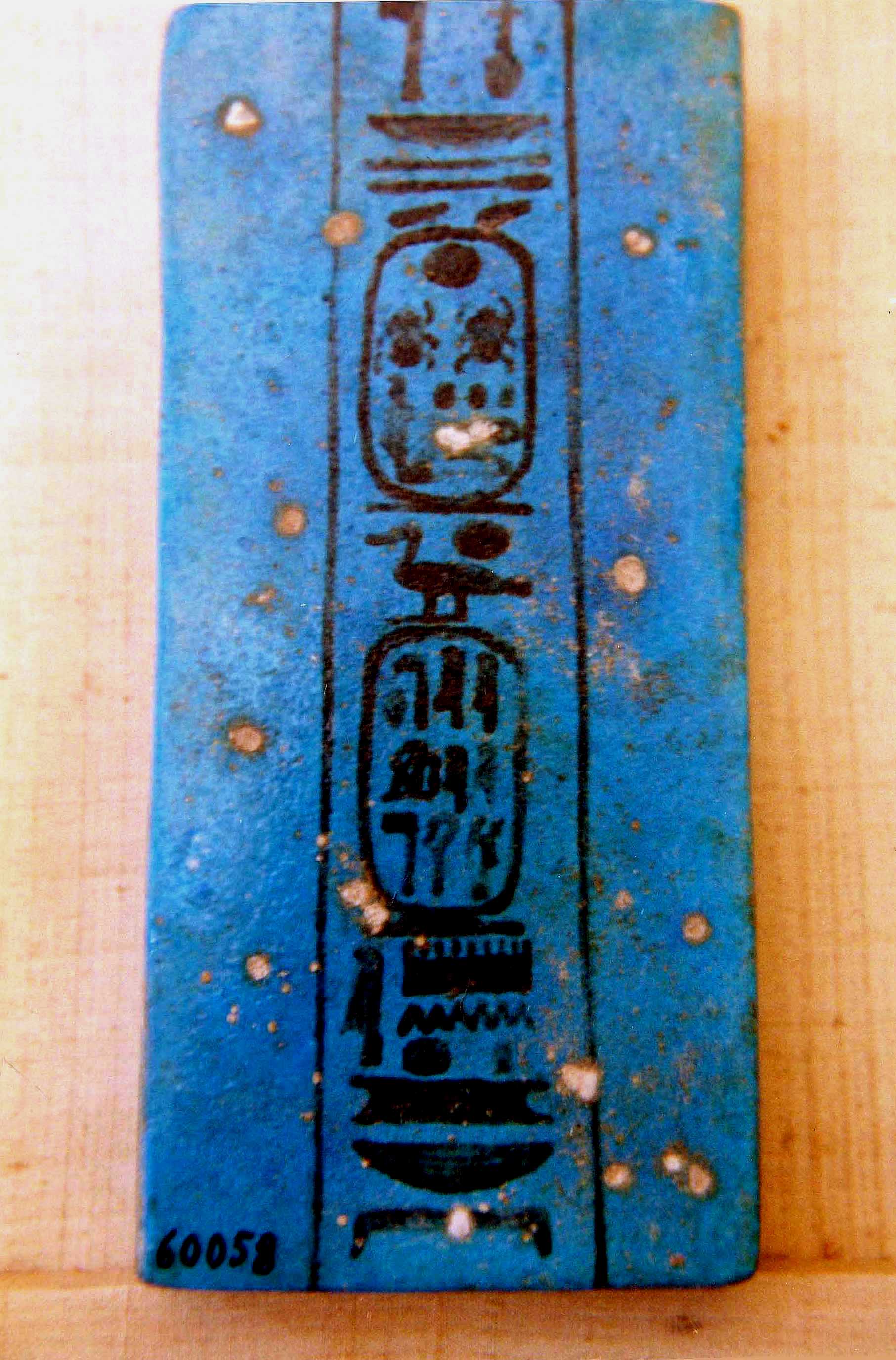
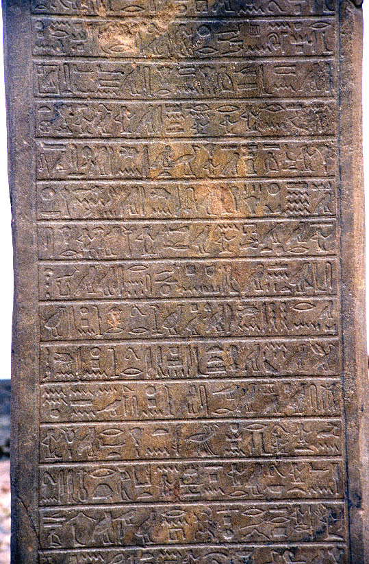
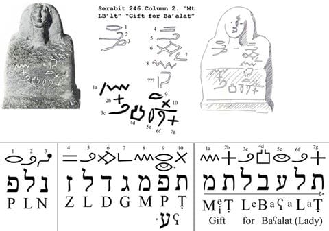
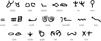
There is another crucial confirmation of the monotheistic character of the Ancient Egyptian settlement at Serabit al Khadim, in spite of the undeniable presence of a small temple dedicated to Ptah that was also excavated there; in any case, contrasting priesthoods coexisted almost always in Ancient Egypt, of course in incessant strife against one another. This issue has to do with something that many specialists observed, studied, published, but never explained. The majestic location is also known for the numerous samples of the so-called Proto-Sinaitic script that are found there. This early alphabetic system is documented due to ca. 40 inscriptions or fragments noticed in the surroundings of the Hathor Temple.
Proto-Sinaitic inscriptions
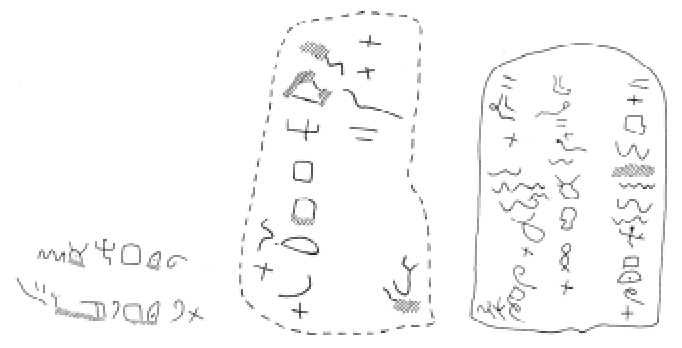
Proto-Sinaitic inscriptions n. 345, 374 and 353
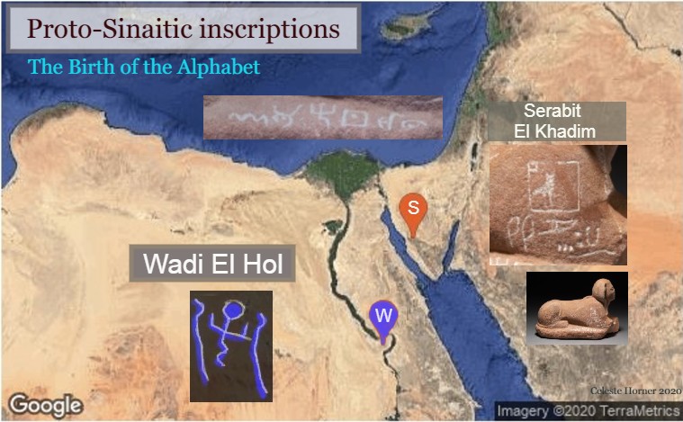
Birth of the Proto-Sinaitic alphabet at Wadi el Hol and Serabit al Khadim
Proto-Sinaitic script on the Sphinx found in Serabit al Khadim
This is an early Canaanite script that seems to be at the very origin of the Phoenician, Hebrew, Aramaic and Greek alphabets from one side, and of the Ancient Yemenite (mistakenly called ‘South Arabian’) script from the other side. The samples are dated in the 1st half of the 2nd millennium BCE (mainly in the period 1800-1600 BCE); they corresponded to a Northwest Semitic language from which seem to originate those of the Ancient Canaanites, the Phoenicians, and the Ancient Hebrews. As texts, the inscriptions of Serabit al Khadim are mainly votive, and they were found among hieroglyphic and hieratic inscriptions. About:
https://en.wikipedia.org/wiki/Proto-Sinaitic_script
https://en.wikipedia.org/wiki/Sinai_Peninsula
Although not abundant, the material record enables us to comprehend what truly was happening in the Hathor Temple. Due to the apparent presence of numerous foreign workers of Northwest Semitic origin, some priestly scribes of the temple decided to introduce a new, relatively easy, writing system among the foreigners. This would closely associate these people with the Hathor priesthood, facilitate the priestly control of them, and finally turn these populations into tools of regional influence; this is so because some of these workers could be dispatched among the tiny Canaanite kingdoms of the 1st half of the 2nd millennium BCE as agents. In fact, during the 18th dynasty (1600-1300 BCE), we observe exactly this type of relationship between Egypt and the various Canaanite tributary princes whose correspondence with the pharaoh has been made known with the discovery of the Amarna Letters.
Saying that we attest in the Serabit al Khadim Hathor Temple around 1700 BCE the preparatory work for what we find in the Egyptian colonies in South Canaan 250 years later may be an understatement. During the Second Intermediate Period of Egypt (1783-1540 BCE) and, more particularly, throughout the time of the notorious 15th dynasty (the Hekau Khasut/Hyksos Kings: 1650-1550 BCE), the wider region around may have been an extraterritorial entity totally out of the hands of the evil and blasphemous kings of Avaris, who were named after the Ancient Egyptian name for Satan (Apep/Apophis). About:
https://en.wikipedia.org/wiki/Second_Intermediate_Period_of_Egypt
https://en.wikipedia.org/wiki/Hyksos
https://en.wikipedia.org/wiki/Avaris
https://en.wikipedia.org/wiki/Apepi
https://en.wikipedia.org/wiki/Apep
At this point, I want to totally reject the unsubstantiated theory of Lina Eckenstein (1857-1931), a pseudo-scientific figure who worked for some time as assistant of the famous English Egyptologist Sir Flinders Petrie; just impressed by the superb site and backed by her skills as failed astrologer and disqualified soothsayer, she claimed that Serabit al Khadim was the location where Moses obtained the Two Tablets with the Ten Commandments. There is nothing in support of this absurd idea. About: Serabit el Khadim, Hathor, Moses, Mount Sinai and the Exodus
https://whatmakespeopletick.blogspot.com/2016/06/serabit-el-khadim-hathor-moses-mount.html
https://en.wikipedia.org/wiki/Lina_Eckenstein
https://en.wikipedia.org/wiki/Tablets_of_Stone
The undeniable fact is however that Biaw (as the Ancient Egyptians named the land that we now mistakenly call ‘Sinai Peninsula’) was administratively considered as an extension of the 14th nome (‘province’) of the Lower Egypt, which was known as the ‘easternmost land’ (‘heneti iabti’; ḫntỉ-ỉꜣbtỉ). This is therefore in evident agreement with the Biblical reference to the land Goshen (where the Ancient Hebrews had settled), which has been identified by many specialists as the northeastern extremities of the Delta. About: https://en.wikipedia.org/wiki/Nome_(Egypt)
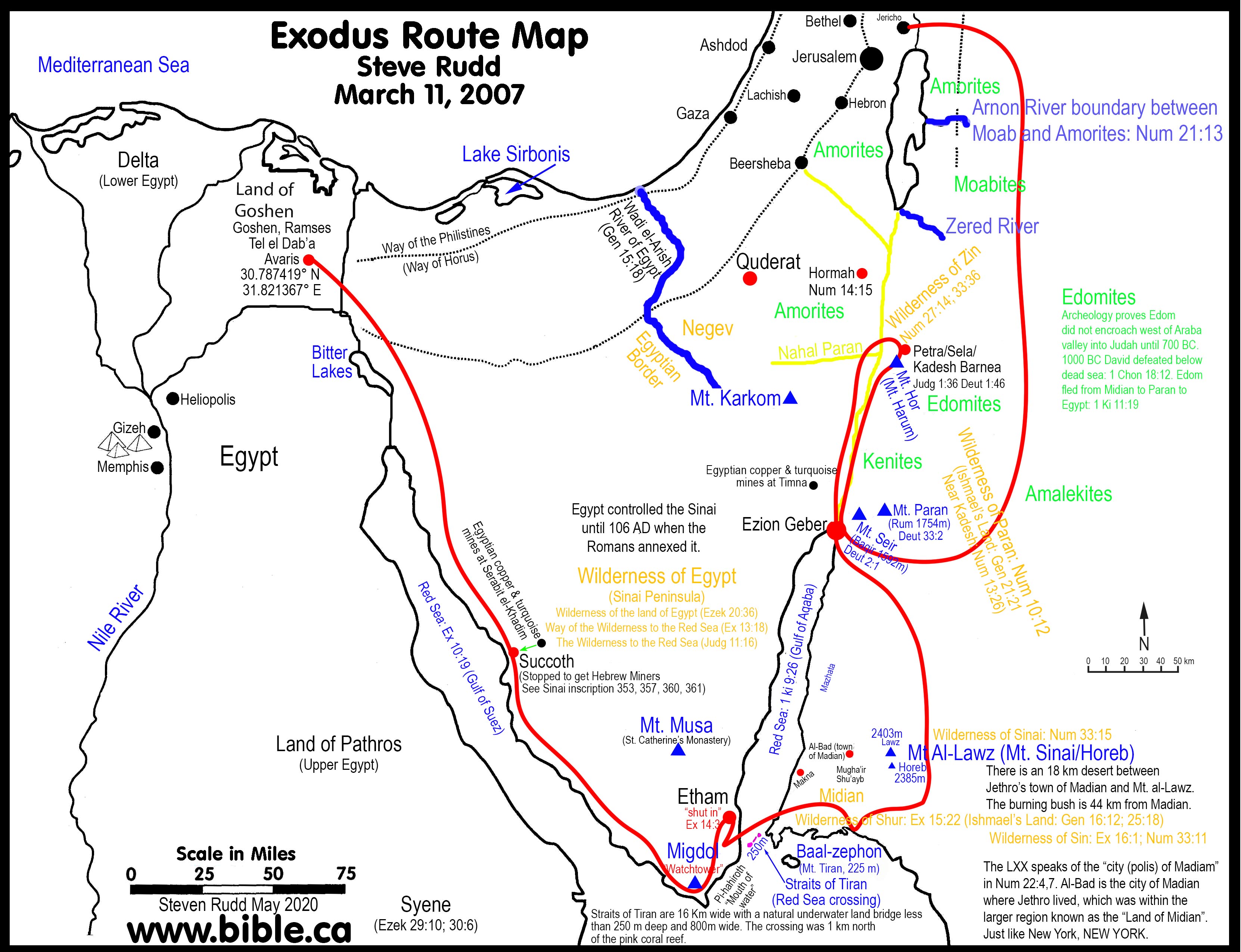
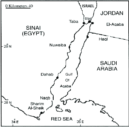
So, we can conclude that it is absolutely misplaced to locate the Crossing of the Red Sea in any of the first four among the five aforementioned alternatives, because in each of those cases, the departing Ancient Hebrews would cross a body of water after which the land would still be part of Egypt. There is in fact only one land toward which the Ancient Hebrews would go without having the fear to find there Egyptian soldiers, officers and Pharaonic administrators: outside Egypt. This means that the Exodus must have most probably taken place from Serabit al Khadim to the southernmost confines of what we call today ‘Sinai Peninsula’ around Sharm el Sheikh, namely any location between the promontories Ras Muhammad and Ras Nasrani.
Then, to offer a plausible answer to all those, who stick to the point that the Biblical Masoretic text mentions ‘yam suph’, which means ‘the Sea of Reeds’ (and not the ‘Red Sea’), one can very reasonably dissociate the Exodus event from the Eastern Delta regions and associate it with the Tiran straits, by merely stating that there may have been reeds in the Tiran straits at the time. Nature has changed significantly over the past 3250 years.
About:
https://en.wikipedia.org/wiki/Ras_Muhammad_National_Park
https://www.tutu.ru/geo/egypt/kurort/ras-nasrani/
https: snorkelaroundtheworld com/2022/08/ras-nasrani-snorkeling/
V. Straits of Tiran: Red Sea Crossing, World Politics, and Moses’ Formidable Double Stratagem
We can therefore conclude that the only plausible itinerary that the Ancient Hebrews and the Egyptian monotheists made after crossing the Straits of Tiran involved the following:
a- wandering through the NW extremities of the Hejaz (in today’s Saudi Arabia);
b- passing by Jabal al-Lawz (جبل اللوز) and Jabal al Maqla (جبل مقلة; lit. ‘burnt mountain’) that several explorers and authors, like Ron Wyatt, Lennart Möller and Bob Cornuke, identified as the Biblical and Quranic Mount Sinai; at this point, I have to add that quite pointlessly several academics, like James K. Hoffmeier, attempted to refute the conclusions drawn by those explorers, without however bringing serious arguments to the forefront of the discussion;
c- crossing certain parts of the Land Midian (מִדְיָן; مدين; Μαδιάμ), which was named after a son of Abraham; I have to herewith add that the Land Midian was quite well known to Moses himself, because according to the Biblical and Quranic sources, the leader of the monotheists, long before the Exodus, had to escape there alone, lest the pharaoh did not kill him (which automatically lets us understand that Moses had a certain experience in crossing those frontiers); and
d- advancing through parts of today’s South Jordan and South Israel, i.e. the Negev desert (הַנֶּגֶב; ٱلنقب; ἔρημος); it must be noted that the modern use of the term covers a slightly different region than the Biblical term. About:
https://en.wikipedia.org/wiki/Straits_of_Tiran
https://en.wikipedia.org/wiki/Tiran_Island
https://en.wikipedia.org/wiki/Midian
https://en.wikipedia.org/wiki/Jabal_al-Lawz
https://ar.wikipedia.org/wiki/جبل_اللوز
https://ar.wikipedia.org/wiki/جبل_مقلة
https://en.wikipedia.org/wiki/Jabal_Maqla
Jebel Al-Lawz
https://www.dangerousroads.org/asia/arabian-peninsula/6495-jabal-al-lawz.html
https://en.wikipedia.org/wiki/Ron_Wyatt
https://en.wikipedia.org/wiki/Lennart_M%C3%B6ller
https://en.wikipedia.org/wiki/Bob_Cornuke
https://baseinstitute.org/pages/mt-sinai
https://www amazon com/Explore-Life-Searching-Locations-Bible/dp/B07WHFC7RM/ref=sr_1_5?qid=1694881140&refinements=p_27%3ABob+Cornuke&s=books&sr=1-5
“The Search for the Real Mount Sinai” w/ Bob Cornuke
https://www youtube com/watch?v=bE_dKLz-v6k
https://en.wikipedia.org/wiki/James_K._Hoffmeier
https://wyattmuseum.com/discovering/mt-sinai
https nypost com/2021/10/02/archaeologist-claims-mount-sinai-found-in-saudi-arabia/
https://www.tovresearch.com/exodus.html
https doubtingthomasresearch com/
(Jim and Penny Caldwell) https://www.splitrockresearch.org/
https://en.wikipedia.org/wiki/Moses_in_Islam
https://en.wikipedia.org/wiki/Moses_in_Islam#Escape_to_Midian_and_Marriage
https://en.wikipedia.org/wiki/Biblical_and_Quranic_narratives#Moses_(M%C5%ABs%C4%81)
https://en.wikipedia.org/wiki/Negev
Spending 40 years to cross these arid lands and circumferences, the monotheists, who followed Moses, in reality, carried out a unique double stratagem; in fact, they left Egypt in the last years of Merenptah’s reign (1213-1203 BCE), and most probably after the early clash between Egypt and the Sea Peoples, namely the Battle of Perire (1208 BCE) during which the Egyptian army managed to disperse the alliance made between the Berbers (Libyans) and the Sea Peoples. The deep religious division that characterized Egypt and the persecution that had taken place totally destabilized the country, which resulted in fanatic polytheists as monarchs and in conspiring viziers, priests, administrators and generals.
This situation became evident after Merenptah’s death, when Seti II (1203-1197 BCE), Amenmesse (as usurper; 1201-1198 BCE), (Seti II’s consort) Tausret (1197-1189; she ruled in reality only after Siptah’s death, but her rule ended in civil war), and Siptah (1197-1191 BCE) ruled in chaotic conditions gravely endangering Egypt’s existence. This means that neither the staunch monotheists’ survival in Egypt was guaranteed nor the very existence of the state promised. The menacing horizon could eventually turn the land of civilization into an inferno of barbarism, if the Sea Peoples won at the battlefield and invaded Egypt. If this occurred, the staunch monotheists under Moses should not be there, but preserve themselves intact in another location. Even more so, because Tausret seems to have been identical with Thuoris (Θούωρις), “who” -as specified by Manetho {Aigyptiaca; Fr. 55 (from Syncellus) According to Africanus}- “in Homer is called Polybus, husband of Alcandra, and in whose time Troy was taken, reigned for 7 years”.
When Setnakhte (1189-1186 BCE), founder of the 20th dynasty and father of Ramesses III, took power in Egypt, very little time was left to Egypt; concealed behind intensely codified Pharaonic names, the few remaining Egyptian monotheists had first to decontaminate the Egyptian army and administrative body from all the subversive agents of the polytheists, namely the Memphitic priests of Ptah and the Theban clergy of Amun, and second to demarcate clearly the polytheist clergy’s role as exclusively sacerdotal of nature with absolutely no impact on the governance of the country.
Ramesses (1186-1155 BCE) had to deliver three battles {as recorded in the inscriptions found on the walls of his mortuary temple at Medinet Habu (Luxor West) in the years 5, 8 (known as the Battle of Djahy; 1178 BCE) and 12 (known as the Battle of the Delta; 1175 BCE} of his reign to save his country and the History of Mankind. Egypt had to exercise its foremost spiritual powers and rely on the most ancient techniques of ethereal potency in order to compactly panic and horrendously confuse the barbarian attackers. So, spiritually dismantled, forcefully subdued, electrically stricken, and magnetically decomposed the defeated Sea Peoples were that they could never recover and actually their scattered parts and tribes never recovered. About:
https://en.wikipedia.org/wiki/Merneptah
https://en.wikipedia.org/wiki/Battle_of_Perire
https://en.wikipedia.org/wiki/End_of_the_19th_Dynasty
https://en.wikipedia.org/wiki/Seti_II
https://en.wikipedia.org/wiki/Amenmesse
https://en.wikipedia.org/wiki/Twosret
https://penelope.uchicago.edu/Thayer/E/Roman/Texts/Manetho/History_of_Egypt/2*.html {Fr. 56 (a) (from Syncellus) According to Eusebius}
https://en.wikipedia.org/wiki/Siptah
https://en.wikipedia.org/wiki/Setnakhte
https://en.wikipedia.org/wiki/Twentieth_Dynasty_of_Egypt
https://en.wikipedia.org/wiki/Ramesses_III
https://en.wikipedia.org/wiki/Battle_of_Djahy
https://en.wikipedia.org/wiki/Battle_of_the_Delta
https://en.wikipedia.org/wiki/Sea_Peoples
And this shows the other half of Moses’ double stratagem; if the Pelasgians-Peleset-Philistines and the other Sea Peoples were successful in their attacks against Egypt, they would control the country, strengthening the religious force of the Memphitic and Theban polytheists (pretty much like two millennia later Charlemagne helped consolidate the power of the heretic Roman Catholic church). In such case, the Philistines would form a strong basis (a military encampment) in the southern confines of Canaan from where they would sustain their presence in Egypt. If the Philistines were defeated (as they actually were), they would apparently scatter (as they did) in the southern coast lands of Canaan, establishing primitive social structures and continuing their lives there (which is what happened).
By spending 40 years in the desert, the staunch monotheists, who followed Moses, took some distance, and gave themselves space and time; thus they could observe what would happen to Egypt and to its ferocious enemies, and then act accordingly. A defeat of Egypt may have sent them back to liberate the country from the evil and barbarian Sea Peoples, but as it happened, this was not needed.
The meaning of the original text of the Exodus was modified later, when the Ancient Hebrew kingdoms needed legends and epics to establish their monarchical ideology and to give themselves the role of the ‘chosen people’, which was the quintessence of the Assyrian imperial universalism, monotheistic dogma, messianic vocation, and eschatological belief. Duly Canaanized, the descendants of the Egyptian and the Hebrew monotheists, who followed Moses in the desert, became a ‘nation’ like the rest and the polytheistic rituals were only one aspect of their spiritual fornication. That is why it is difficult to understand the Biblical prophets: because the Egyptian past of the Ancient Hebrews was methodically de-contextualized long before this populace attributed to themselves a role invented by others in Mesopotamia, and not in Egypt.
But it is only due to this interpretation that Hosea (Ὡσηὲ) becomes meaningful (7:11): “And Ephraim was as a silly dove, not having a heart: he called to Egypt, and they went to the Assyrians” (καὶ ἦν Ἐφραὶμ ὡς περιστερὰ ἄνους οὐχ ἔχουσα καρδίαν· Αἴγυπτον ἐπεκαλεῖτο καὶ εἰς Ἀσσυρίους ἐπορεύθησαν).
VI. Iranians, Macedonians, Aramaeans, Romans: Reasons for the Confusion about the True Location of Mount Sinai
The confusion, which later covered the topic of the true location of Mount Sinai, has much to do with the numerous divisions (Cushitic-Sudanese pharaohs of the 25th dynasty vs. Berber-Libyan pharaohs of the 26th dynasty) and the various, successive conquests of Egypt (Assyrian, Iranian, Macedonian, and Roman), the loss of the largest part of Ancient Hebrews (conquest of Samaria by Sargon/Sharrukin II and transportation of the entire population of Ancient Israel, i.e. the ten tribes, to the northeastern provinces of Assyria; 721-718 BCE), the extensive destructions that took place during the conquest of Judah, namely the remaining two tribes, and Jerusalem (589-586 BCE) by the Babylonian king Nebuchadnezzar, and the overwhelming transformation of the Ancient Hebrew religion into ‘Judaism’ during the Achaemenid times (550-330 BCE).
As a matter of fact, the very last indication that we have about Ancient Hebrews remembering correctly the location of Mount Sinai (or Horeb) is found in III Kings 19:8 (in modern English translations, such as NIV: I Kings 19:8); Elijah needed indeed ’40 days and 40 nights’ in order to reach the location (“So he got up and ate and drank. Strengthened by that food, he traveled forty days and forty nights until he reached Horeb, the mountain of God”; “καὶ ἀνέστη καὶ ἔφαγε καὶ ἔπιε· καὶ ἐπορεύθη ἐν ἰσχύϊ τῆς βρώσεως ἐκείνης τεσσαράκοντα ἡμέρας καὶ τεσσαράκοντα νύκτας ἕως ὄρους Χωρήβ”).
The most probable reason for the ensued confusion must be the fact that the long duration of the Iranian, Macedonian (: mainly Ptolemaic) and Roman occupation and administration of Egypt involved also the annexation and government of Palestine (or Judea) by the said empires; this resulted in new demarcation lines, administrative changes, and transfer of lands from one province to another, as different parameters weighed in to improve the local governance and the province functionality or also cross-province functionality. The aforementioned changes that impacted the topic of our research (namely the confusion about the exact location of the Biblical Mount Sinai/Horeb) concern basically two issues:
-the ‘Sinai Peninsula’ (to use the modern name of the region) started being viewed as part of Palestine (and at times, of ‘Arabia Petraea’: see below), and not of Egypt;
-the demarcation of boundaries between Palestine (at times called Judea) and Arabia Petraea varied from time to time. In this regard, several changes were not accepted unanimously, more particularly because they were meaningless to different people. Consequently, these changes were not reflected in their historical sources.
With the importance that the Gulf of Suez and the Gulf of Aqaba acquired for the Achaemenid Empire and following the circumnavigation of the Arabian Peninsula, the ‘Sinai Peninsula’ became an important region for the transportation of trade (and eventually army) from the Persian Gulf to Egypt and vice versa.
With the increased role that the Aramaean merchants acquired within and beyond the borders of Iran, we observe a growing number of Aramaean trade colonies being established across the vast trade network that we nowadays conventionally call ‘the Silk-, Spice- and Perfume-Routes across Lands, Deserts and Seas’. This does not only concern the famous caravan cities, like Hatra, Nasibin (Nisibis), Urhoy/Urfa (Edessa of Osrhoene), Tadmor (Palmyra), Dura Europos, Rekem/Petra, some of which were the capital cities of rather short-lived kingdoms; it also involves the foundation of new cities like Qena (Kaine; Καινή), an Aramaean outpost in Upper Egypt, Gerrha (Γέρρα), a major Chaldean Aramaean entrepôt and port of call in the Persian Gulf (ca. 100 km west of Abu Dhabi in today’s UAE coast land), which rivaled with or even surpassed Alexandria in wealth, and Ptolemais Theron (Islamic times’ Suakin / Sawakin), a Ptolemaic colony in Sudan’s Red Sea coast land (east of the continental kingdom of Cush that had Meroe as capital).
These developments ushered the local people into a totally new world, which was highly interconnected, markedly multicultural, and open to new faiths, mysticisms, cults and interpretations; however, within a shell of universality, interdependence and cohabitation, many atrocities could happen and did actually happen.
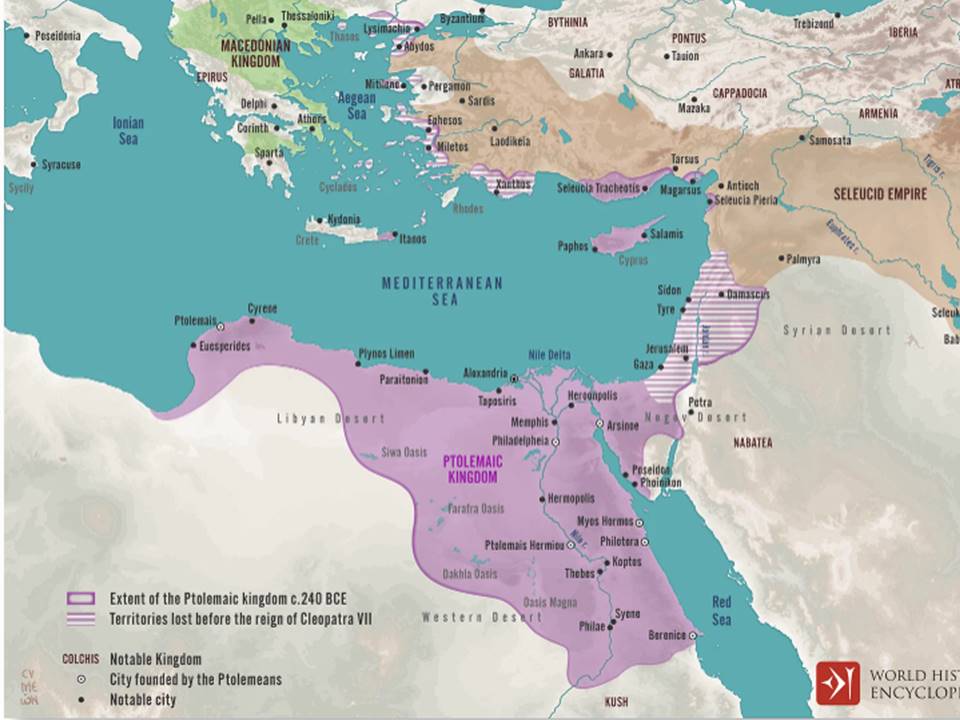

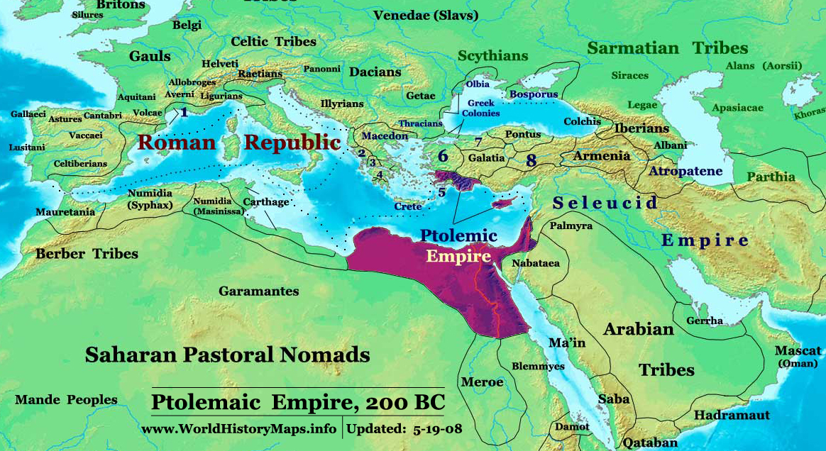
The Egyptian Ptolemaic control over Sinai was not the first period during which the southern parts of Canaan and the Sinai Peninsula were parts of Kemet (: the most common name of Ancient Egypt in Egyptian hieroglyphics meant ‘the Black Land’); however, it was the first time when so many non-Egyptians were present and active in those regions: Iranians, Aramaeans, Yemenites and some Arabs. The entire area had a major strategic role as it was the borderland between Egypt and Seleucid Syria, a mighty opponent. Leaving aside the periods of Assyrian and Iranian occupation of Egypt, the Ptolemaic-Seleucid conflict was a real historical ‘remake’ of the Hittite-Egyptian rivalry.
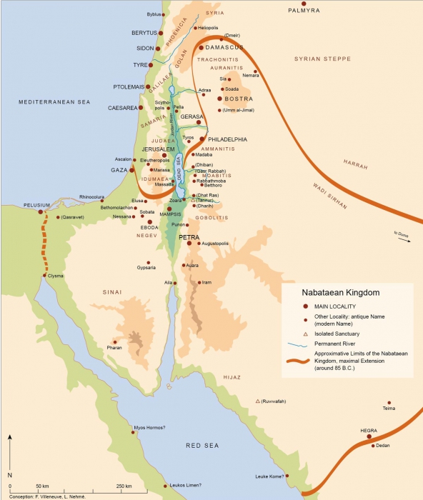
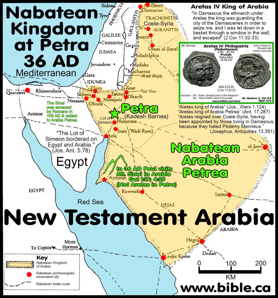
This situation triggered the inception of the Aramaean Nabataean kingdom (3rd c. BCE – 106 CE), which -with capital at Rekem/Petra (Πέτρα) and necropolis at Hegra (Έγρα; ٱلْحِجْر) / Mada’in Saleh (مَدَائِن صَالِح)- controlled a sizeable territory including the northwestern confines of today’s Saudi Arabia (Hegra is located 560 km south of Petra and only 360 km north of Medina), the southern half of the modern kingdom of Jordan, and occasionally the eastern part of the Sinai Peninsula and the southern half of the state of Israel. It is noteworthy that, even without a proper kingdom in their hands, the indomitable Nabataean Aramaeans were able to inflict a very humiliating defeat on the Macedonian general Antigonus I Monophthalmus (the ‘one-eyed’) in 312 BCE (during the Third War of the Diadochi), when the inconsiderate combatant had adventured in the whereabouts of Petra.
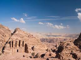
Rekem / Petra
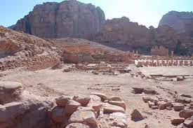
Rekem / Petra
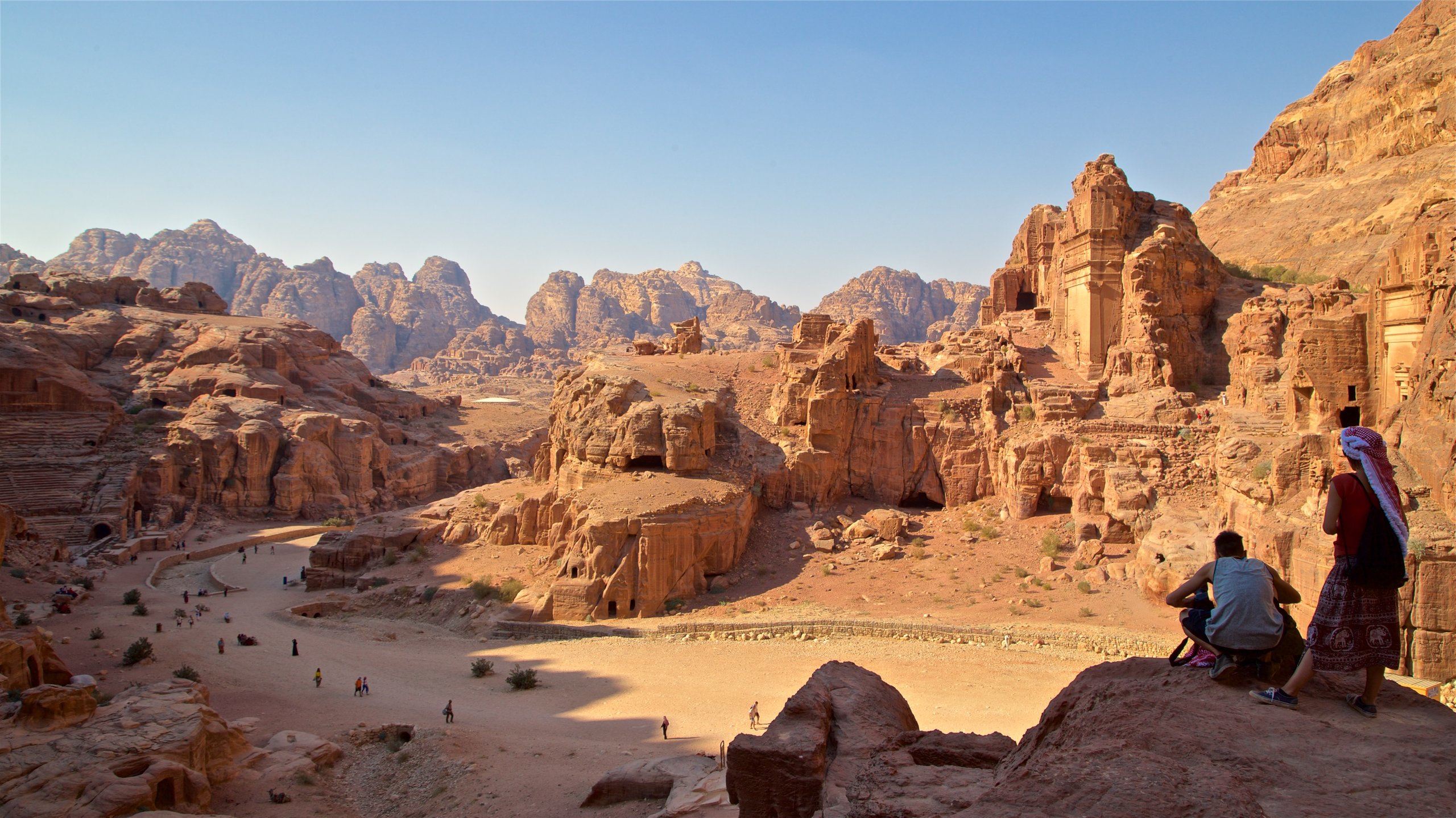
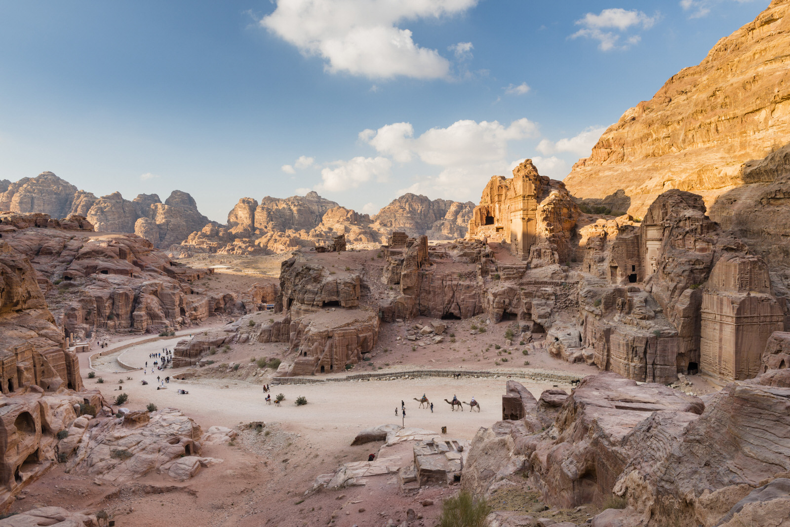
Rekem / Petra
Hegra / Mada’in Saleh
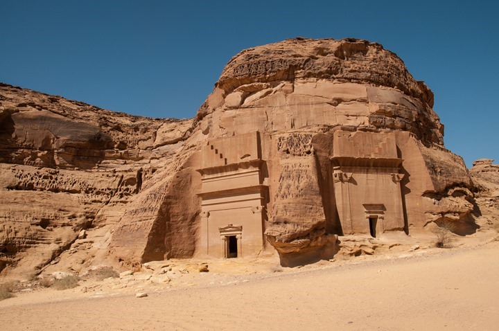
Hegra / Mada’in Saleh
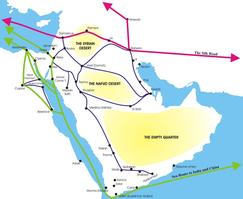
The Nabataean kingdom played an important role in the increased trade between Alexandria and India, and if we believe the comparisons made by the partially pro-Roman Strabo, it had an even more significant position in the dramatically increased trade between Rome and China in the first decades after Octavian’s invasion and annexation of Egypt. The transformation of Egypt into a Roman province (30 BCE), the end of the Hasmonean kingdom of Herod the Great (37-4 BCE), and the short-lived Herodian Tetrarchy (4 BCE – 44 CE) only accentuated the importance of the Nabataeans, who accumulated great wealth due to the control of a part of the trade with the East that they were able to undertake.
The Roman conquest of Jerusalem (70 CE) in particular, the three Roman-Jewish wars in general {namely the First Roman-Jewish War (66-73 CE), the Second Roman-Jewish War (also known as Tumultus Iudaicus or the Kitos War, after the name of the Berber Roman general Lusius Quietus/Λούσιος Κυήτος, who was the 11th legate of Judaea; 115-117 CE), and the Bar Kokhba revolt (132-136 CE)}, and the ensued stupendous destructions, involving the death, the enslavement, and the dispersion of a great number of Jews, also contributed to the lack of knowledge (and therefore confusion) about the location of the Biblical Mount Sinai.
As a matter of fact, the Nabataean kingdom was imperatively mentioned in the leading historical source about the trade between Alexandria, East Africa, Yemen, Iran, India, the Deccan, and China, namely the Periplus of the Red Sea (Περίπλους της Ερυθράς Θαλάσσης; also known as the Periplus of the Erythraean Sea), which was written during the second half of the 1st c. CE by an anonymous Egyptian Alexandrian captain and merchant; the text details the navigation, the trade, the local societies, kingdoms, and ports of call, as well as the climatological imperatives throughout the Eastern coast of Africa (down to today’s Darussalam in Tanzania), the coasts of Arabia, Yemen, Iran, India and the Deccan, and up to Chryse (lit. ‘the Golden’, i.e. Indonesia) and China. In its 19th paragraph, the Periplus of the Red Sea mentions the Aramaean Nabataean king Maliku (Malichus II):
“Now to the left of Berenice, sailing for two or three days from Mussel Harbor eastward across the adjacent gulf, there is another harbor and fortified place, which is called White Town, from which there is a road to Petra, which is subject to Malichas, King of the Nabataeans. It holds the position of a market-town for the small vessels sent there from Arabia; and so a centurion is stationed there as a collector of one-fourth of the merchandise imported, with an armed force, as a garrison”.
In the beginning of the 2nd c. CE, it became very clear that the Nabataean profit meant expensive products for Rome; following the death of Rabbel II (106 CE), Roman army was dispatched from Syria (the Sixth Ferrata legion) and Egypt (the Third Cyrenaica legion) to terminate the local structure and annex the territory. After invading Bosra (Βόστρα) and Petra, the Romans advanced in the south down to Hegra, also putting Leuke Kome (Λευκή Κώμη; White Town) under control. The events took place shortly before Trajan’s expeditions against Parthia (Arsacid Iran), during which (114-117 CE) Trajan proved to be the only Roman emperor to have reached the western shore of the Caspian Sea and the creek of the Persian Gulf in person.
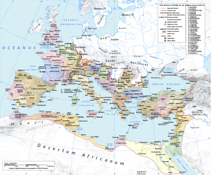
Roman Empire around 125 CE
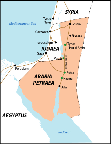
It was then (107-110 CE) that, during the tenure (106-116 CE) of the Greek Pontic Gaius Claudius Severus as the first governor of the new Roman province, the Via Traiana Nova (‘Trajan’s New Road’) was constructed to link Bosra and Petra with Aelana (modern Eilat in Israel and Aqaba in Jordan), and the Limes Arabicus (the desert frontier of the Roman Empire) was demarcated, involving the building of fortresses and watchtowers. The ultimate consequence of all these developments was the inception of the Roman province of Arabia Petraea.
Last, an even greater change, which took place as a consequence of the Roman annexation of the Nabataean kingdom, was the introduction of the Bostran Era, which was a lunisolar calendar that started on 22nd March 106 CE. The names of the months corresponded to those of the ancient Macedonian calendar, but the existing documentation (in Aramaic, Nabataean, Arabic and Alexandrian Koine) preserved mostly the Aramaean Nabataean equivalents. Furthermore, the Bostran Era was the calendar of all the Arab and Yemenite Christians in pre-Islamic times; it was still in use at least 100 years after the Hijri calendar was introduced among Muslims, in spite of the explicit rebuttal of the lunisolar calendars by prophet Muhammad (a position that was due to the fact that these calendars necessitate intercalary months).
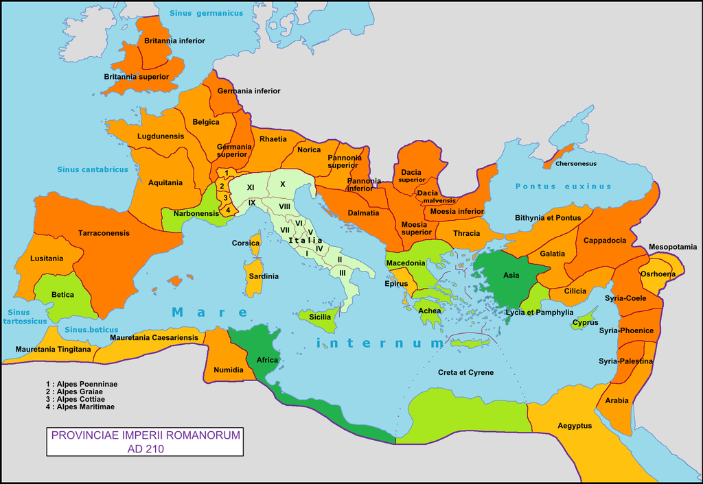
Petra became the capital of the Roman province ‘Arabia Petraea’ (106 CE); initially, this province incorporated lands of Syria south of Damascus, the western part of Jordan, the Sinai Peninsula, and the NW confines of Saudi Arabia. The part between Petra and Bosra was the true center of gravitation in the new province; major cities or urban centers involved notably Philadelphia (today’s Amman), Gerasa (Jerash/ جرش; Γέρασα), etc. At the time, the Roman Province Judea still existed, but it was merged with Syria in 135 CE. Arabia Petraea remained a province of the Roman Empire and later the Eastern Roman Empire for more than 600 years, being a rather peaceful frontier zone.
Following a local rebellion, under Septimius Severus (193-211 CE), the Roman province of Syria was divided into three parts, namely Syria-Coele, Syria-Phoenice, and Syria-Palestina (Palaestina); this surely increased the importance of Arabia Petraea, taken into consideration the rivalry of the two provinces that had already lasted for a century. The Roman Emperor even enlarged the territory of the loyal province.
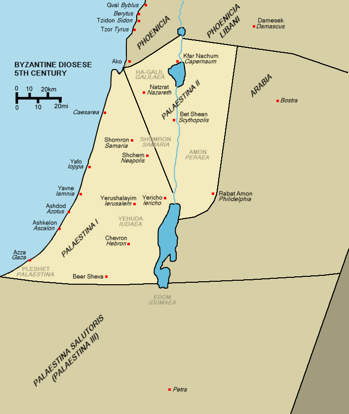
Later, during the process of restructuring of the Roman Empire under Diocletian (284-305 CE), the southern part of the province of Arabia Petraea was transferred to Syria-Palestina; it then became a division of the ‘Diocese of the East’ (Dioecesis Orientis), which was a major component of the Praetorian prefecture of the Orient (Praefectura Praetorio Orientis; Ἔπαρχότητα / ὑπαρχία τῶν πραιτωρίων τῆς ἀνατολῆς). Last, during the 4th c., Palestina was divided into three sections, namely Palaestina Prima, Palaestina Secunda, and Palaestina Salutaris (or Tertia), which incorporated the Sinai Peninsula. Arabia was then shrunk into a small piece of land between Bosra and Philadelphia (Amman). Petra was included in Palaestina Salutaris.
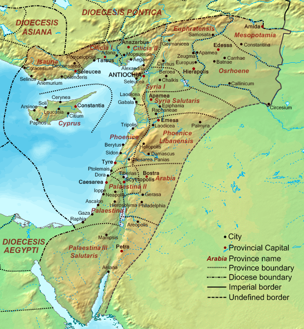
Diocese of the East – Dioecesis Orientis, ca. 400 CE
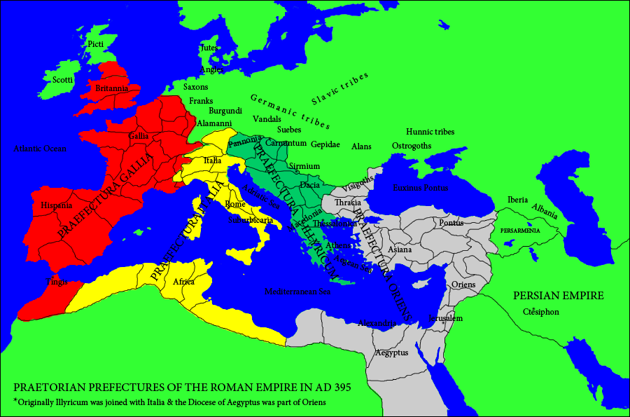
Praetorian Prefectures, and the Praetorian prefecture of the Orient
Palaestina Prima, Palaestina Secunda, and Palaestina Salutaris (or Tertia)
Subsequently, the confusion about the geographical and administrative terms ‘Egypt’, ‘Palestine’, and ‘Arabia’ was plain and the uncertainly about the correct location of the Biblical Mount Sinai was absolute. For this reason, the Tiran Island (جزيرة تيران; יוטבת; Ἰωτάβη; Iotapa) was represented Council of Chalcedon (451 CE) by bishop Macarius whose diocese belonged to the Eastern Roman province Palestina Tertia (and not to Arabia or Egypt). The same is valid for bishop Anastasius of Iotapa, who participated in the Council of Jerusalem (536 CE). It was an absurdity that the Tiran Island (Iotabe) was considered to be part of ‘Palestine’ and at the same time, the Sinai Mountain was believed to be located where it is thought to be today, but the confused minds of the people of those days were not able to discern it.
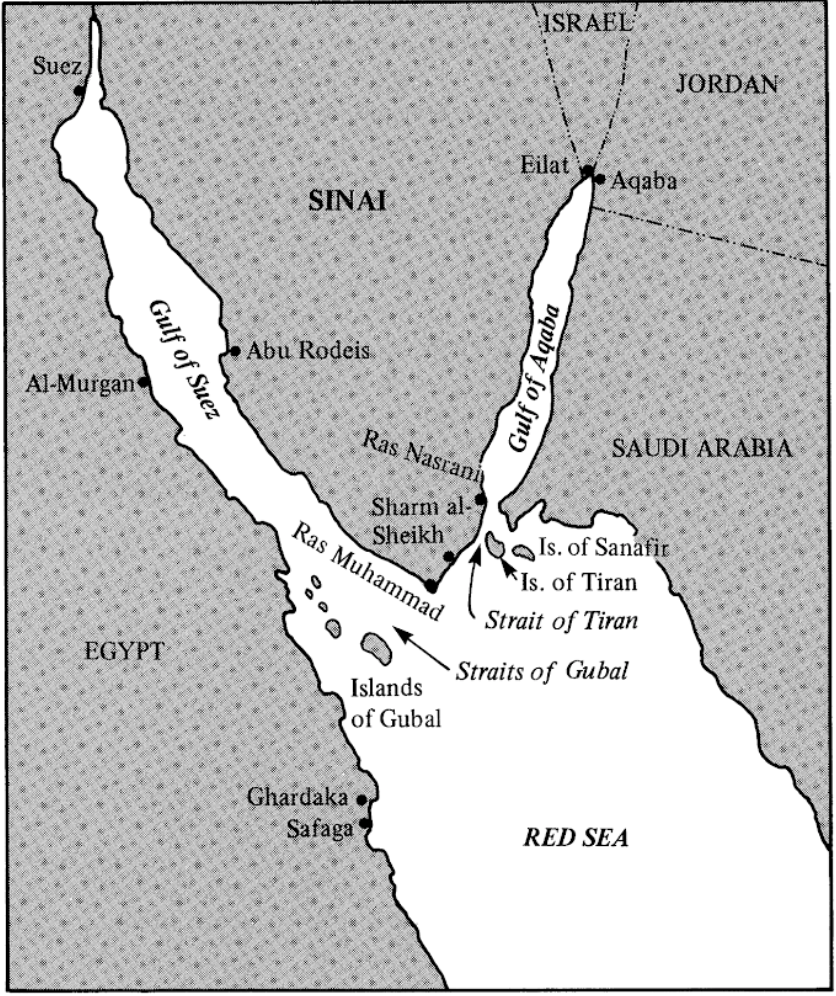
The Tiran straits
About:
https://en.wikipedia.org/wiki/Ptolemaic_Kingdom
https://en.wikipedia.org/wiki/Nabataean_Kingdom
https://en.wikipedia.org/wiki/Antigonid%E2%80%93Nabataean_confrontations
https://en.wikipedia.org/wiki/Desert_of_Paran
Philip Mayerson, The Pharanitai in Sinai and in Egypt {The Bulletin of the American Society of Papyrologists Vol. 47 (2010), pp. 225-229 (5 pages)}
https://www.jstor.org/stable/24519797
https://en.wikipedia.org/wiki/Herodian_kingdom
https://en.wikipedia.org/wiki/Herodian_tetrarchy#See_also
https://en.wikipedia.org/wiki/Siege_of_Jerusalem_(70_CE)
https://en.wikipedia.org/wiki/First_Jewish%E2%80%93Roman_War#Aftermath
https://en.wikipedia.org/wiki/Kitos_War
https://en.wikipedia.org/wiki/Lusius_Quietus
https://en.wikipedia.org/wiki/Bar_Kokhba_revolt
https://en.wikipedia.org/wiki/Jewish%E2%80%93Roman_wars
https://en.wikisource.org/wiki/Periplus_of_the_Erythraean_Sea#Periplus
https://en.wikipedia.org/wiki/Rabbel_II_Soter
https://en.wikipedia.org/wiki/Bosra
https://en.wikipedia.org/wiki/Trajan#Nabataean_annexation
https://en.wikipedia.org/wiki/Leuke_Kome
https://en.wikipedia.org/wiki/Via_Traiana_Nova
https://en.wikipedia.org/wiki/Gaius_Claudius_Severus
https://en.wikipedia.org/wiki/Limes_Arabicus
https://en.wikipedia.org/wiki/Arabia_Petraea
https://upload.wikimedia.org/wikipedia/commons/d/dd/Roman_Empire_125_political_map.svg
https://en.wikipedia.org/wiki/Bostran_era
https://en.wikipedia.org/wiki/Nasi%27
https://en.wikipedia.org/wiki/Diocese_of_the_East
https://en.wikipedia.org/wiki/List_of_Late_Roman_provinces#Diocese_of_Oriens
https://en.wikipedia.org/wiki/Tiran_Island#Ancient_history_-_Iotabe
https://en.wikipedia.org/wiki/Council_of_Jerusalem_(536)
https://en.wikipedia.org/wiki/Palaestina_Salutaris
VII. From Ptolemy’s Geography to Al Biruni’s Chronology
Writing his illustrious Geography (Γεωγραφικὴ Ὑφήγησις; lit. ‘Instruction on Geography) in the first half of the 2nd c. CE, the Egyptian geographer, astronomer and mathematician Ptolemy divided the Arabian Peninsula into three parts, namely
a- Arabia Petraea (lit. ‘Rocky Arabia’), which basically consisted in a mountainous region stretched from the Gulf of Aqaba (Ελανίτης κόλπος; Elanite Gulf) to the southern confines of Syria and Palestine (or Judaea) and from the Gulf of Suez to the desert inland (which was called Arabia Deserta); this means that it included the entire region that we now call ‘Sinai Peninsula’. Among the cities mentioned by Ptolemy, we find Petra, Gerasa, Bosra and Elana (Ελάνα; Eilat/Aqaba) in the creek of the Elanite Gulf.
b- Arabia Deserta (Έρημος Αραβία); as per Ptolemy’s Geography, this region was located south of ‘Mesopotamia’, west of Babylonia (which is the land we now call ‘South Mesopotamia’), east of Syria, Palestine and Arabia Petraea, and north of Arabia Felix (see below); this means that this part comprised the vast interior of the peninsula, involving several deserts, namely the Najd, the Nafud, the Dahna, and the Rub’ al Khali. Arabia Deserta was therefore thought of as totally deprived of coastlands.
c- Arabia Felix (or Eudemon Arabia; Ευδαίμων Αραβία); many modern scholars identify this region with just Yemen and Hadhramaut (the former states of North and South Yemen), but this is very wrong; a careful reading of Ptolemy’s Geography enables us to fully comprehend that the term ‘Arabia Felix’ denotes the following lands:
i- the long, mountainous region stretched (alongside the Red Sea coast of the Arabian Peninsula) from the Gulf of Aqaba to the oasis of Najran, which is the northernmost part of Yemen (being currently occupied by Saudi Arabia); ca. 1400 km long and about 100-150 km wide, this zone corresponds vaguely to the geographical term Hejaz (الحجاز) of the Islamic times. The Arabic term denotes the ‘barrier’, meaning the mountains that separate the desert (in the east) from the Tihamah plain (in the west). This narrow and oblong plain is located between the western slopes of those mountains and the Red Sea shore;

ii- the aforementioned lands that are regularly identified as ‘Arabia Felix’ by modern scholars, namely Yemen and Hadhramaut; and
iii- the lands of the modern states of Oman, UAE, and Qatar, as well as the Saudi coast land in the Persian Gulf almost up to today’s Kuwait. However, it has to be added that these Ancient Greek and Latin terms were used to also denote the city and harbor of Aden, which was the major entrepôt and port of call throughout the Arabian Peninsula (mentioned in the paragraph 26 of the Periplus of the Red Sea as part of the then merged kingdoms of Sheba and Himyar).
It goes without saying that the Roman province of Arabia Petraea was only a small part in the north-westernmost confines of the Arabian Peninsula. Contrarily, Arabia Deserta and Arabia Felix comprised of the major chunks of the peninsula. It is quite interesting to note that Ptolemy the Geographer describes the location and details the sites (and their positions) of Arabia Petraea in the seventeenth chapter of the fifth book of his masterpiece. The Greek text is available here – on p. 68 (Lib. V, cap. 17):
Ptolemy then proceeds with the description and the details of Mesopotamia (on p. 70; Lib. V, cap. 18) and dedicates the 19th (penultimate) chapter of the 5th book to the presentation of Arabia Deserta (p. 74). The last (20th) chapter of this book concerns Babylonia, i. e. South Mesopotamia. After the end of this book, the 6th book starts with the presentation of Assyria, Media, Susiana, Persis, Parthia, and the Desert of Kerman (Καρμανία Έρημος). Then, the seventh chapter of the sixth book concerns Arabia Felix (on p. 97). I expand on the way the great scholar of the Late Antiquity classified and presented his explorations, data, studies and conclusions, because it is essential for every reader today to understand that the Earth in general and the various lands more particularly were viewed very differently at the time. About:
https://en.wikipedia.org/wiki/Hejaz
https://en.wikipedia.org/wiki/Arabia_Felix
https://en.wikipedia.org/wiki/Arabia_Deserta
https://en.wikipedia.org/wiki/Arabia_Petraea
https://en.wikipedia.org/wiki/Najd
https://en.wikipedia.org/wiki/Nafud_desert
https://en.wikipedia.org/wiki/Ad-Dahna_Desert
https://en.wikipedia.org/wiki/Rub%27_al_Khali
https://en.wikipedia.org/wiki/Geography_(Ptolemy)#Content
This is how Ptolemy the Geographer describes the confines of Arabia Petraea (§ 5.17.1):
«Arabia Petraea is bounded on the west by that part of Egypt to which we have referred; on the north by Palestina or Judaea and the part of Syria along dividing line; on the south by the inmost point of the Arabian gulf, at 63°30′ & 29°50′ and by the Heroopolite gulf from the limit of Egypt up to the Pharan promontory, which is located at 65°00′ & 28°30′ and by the near side of the Elanite gulf, until its return at 66°00′ & 29°00′ The position of Pharan Kome is .65°00′ & 28°40′ Elana Kome, which is located in the inmost recess of the bay of this name, has this position 65°50′ & 29°15’».
As I already pointed out, the Elanite Gulf is the Gulf of Aqaba; I further clarify now that the Heroopolite gulf is the Gulf of Suez. An English translation (Arabia Petraea: paragraph 5.17.1; Arabia Deserta: paragraph 5.19.1; and Arabia Felix: paragraph 6.7.1) is available here: https://topostext.org/work/209
About:
https://en.wikipedia.org/wiki/Heroopolite_Gulf
https://en.wikipedia.org/wiki/Desert_of_Paran
https://nabataea.net/explore/founding_of_islam/ptolemy-and-mecca/
Writing no less than 850 years after Ptolemy completed his Geography, Al Biruni (البيروني; Abu Rayhan Muhammad ibn Ahmad al-Biruni being his complete name; 973-1048) referred to the Exodus in his grand opus ‘Chronology’. The complete title of the majestic opus is (کتاب الآثار الباقية عن القرون الخالية/Kitab al-athar al-baqiyah ‘an al-qurun al-khaliyah) ‘the Remaining Signs of the Past Centuries’; it was completed around the year 1000. According to conventional wisdom, this masterpiece consists in a comparative investigation, discussion, and presentation of different calendars and chronological systems that were in use among people of different religions, cultures and countries.
It goes without saying that, to undertake such an enormous effort, the Chorasmian (Khawarizmi) Iranian erudite scholar Al Biruni (whose name originates from the Farsi word ‘birun’ which means ‘the periphery’ or ‘the suburbs’, thus denoting that the person was born outside an urban center) had learned and was able to read Syriac, Hebrew, Sanskrit and Greek, in addition to Farsi, Arabic, and several other Iranian and Turanian languages. To proceed to this research, Al Biruni was already highly knowledgeable in, and well acquainted with, Zoroastrianism, Hinduism, Buddhism, Christianity (involving Orthodoxy, Monophysitism/Miaphysitism, and Nestorianism), Judaism, Gnosticisms and Manichaeism. In addition, he had clearly accumulated an impressively vast documentation.
However, Al Biruni’s Chronology is much more than the display of highly valuable skills in diverse fields, such as mathematics, linguistics, astronomy, physics, history of religion, geography, ethnography, and wisdom, which is an Islamic field superior to ‘philosophy’. A brief look at the Table of Contents of his superb treatise (involving 21 chapters) is quite convincing.
Before expanding on the calendars, the months, and the festivals of the Persians, the Sogdians, the Chorasmians (Khawarizmis), the Greeks, the Jews, the Christians, the Nestorians, as well as those of the Mithraic Magi, the Sabians, the pre-Islamic Arabs, and the Muslims, Al Biruni wrote entire chapters on ‘the Derivation of the Eras from each other’, ‘the different Opinion of various Nations regarding the king called Dhu-al Qarnayn’, ‘the Nature of the Eras’, and ‘the Nature of that which is composed of Days, viz. Months and Years’. This shows that the quintessence of the Science that he served, explored and developed was totally different from what people today believe as ‘science’; this is so because for Al Biruni the material universe could not possibly exist without being fully parameterized after the spiritual universe. About:
https://en.wikipedia.org/wiki/Al-Biruni
https://en.wikipedia.org/wiki/The_Remaining_Signs_of_Past_Centuries
At the end of his 6th chapter, titled ‘On the Derivation of Eras from each other, and on the Chronological Dates, relating to the Commencements and the Durations of the Reigns of the Kings, according to the various Traditions’ (p. 87 of the book; p. 108 / 492 of the PDF, ed. C. Edward Sachau, London, 1879; see link above), Al Biruni writes the following paragraph in order to introduce a table of data, which is presented afterwards:
«The following is a synopsis of the years of their rulers, who ruled over them after their exodus from Egypt, when they marched towards Bahr al-Kulzum (the Red Sea) in order to pass it, and to Altih, a desert in Alhijaz, in the direction of Jerusalem».
The appellation Bahr al-Kulzum of the Red Sea is due to the Arabization of the Greek toponym Clysma (Κλῦσμα), which was a city and fortress (or military encampment) close to Arsinoe (today’s Suez) that was Ptolemaic and Roman Egypt’s greatest port of call in the Red Sea. During the Islamic ages, the use of the geographical term Bahr al-Kulzum differed from time to time and from author to author, meaning either the Gulf of Suez or the Red Sea down to the Straits of Bab al Mandeb.
The term «Altih desert» is a unique expression; quite interestingly, the term «التيه» (altih), including the Arabic article, is the very typical word used with respect to the desert that the Ancient Hebrews crossed after the Exodus and the Red Sea Crossing. The most interesting part of the excerpt is however Al Biruni’s firm designation of Altih desert as a location in Hejaz, not the peninsula that we call now Sinai. About:
https://ar.wikipedia.org/wiki/تيه
https://en.wikipedia.org/wiki/Clysma
https://en.wikipedia.org/wiki/Arsinoe_(Gulf_of_Suez)
Taking into consideration both, the period in which Al Biruni lived and wrote his grand opus and his strong acquaintance with Christians and Christian historical sources, we understand that, at a time when most of the Christians believed that the Biblical Mount Sinai was located in the whereabouts of St. Catherine Monastery, the correct knowledge about the original location of the holy place was still maintained among erudite scholars. As a matter of fact, the term Hejaz was never attributed to the land we now -mistakenly- call Mount Sinai. However, extensive research is urgently demanded for the whereabouts of Jebel al Lawz in order to confirm what many explorers were already able to deduce one way or another.
————————————————————————————————–
Download the article (text only) in PDF:
Download the article (with 107 pictures and legends) in PDF:


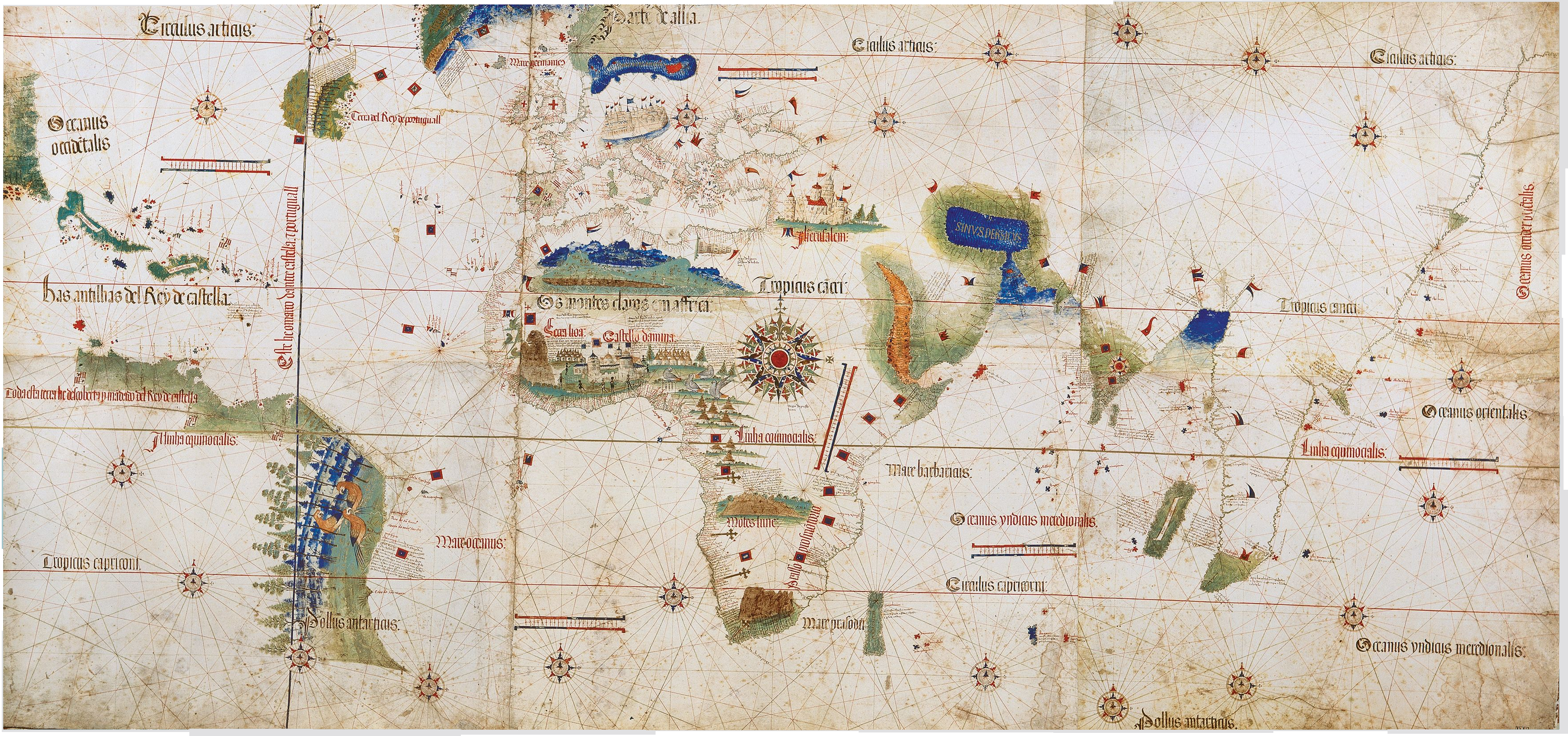


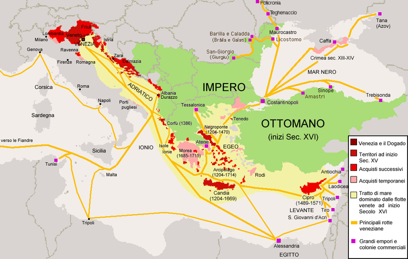


